Tag Archives: #photogrammetry

xyHt News Links: 9/2/16
Satlab New Product Announcement: SLC Handheld Four land surveyors share their experiences of using professional drones in their work. Airobotics Selects SimActive’s Photogrammetry Software for its Automated Industrial Drone Solution Carlson Software Releases BRx6 GNSS Receiver New Kespry Drone 2.0 Has Twice the Aerial Coverage senseFly launches new drone Property Drone Consortium and Marion County,...
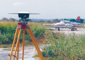
We Are Aviators First
With UAS, surveyors are becoming aviators. As we adopt new technology, we should heed old advice. I flew my first photogrammetric mission in the early 1980s while I was completing my geodesy degree during tumultuous times at my alma mater. While the rest of the world had disco fever, students at Universidad Central de Venezuela...

Copter Power
A UAS rotocopter pilot directs the successful imaging of a breakwater project in Costa Rica. Unmanned aircraft systems (UAS) are finding their way into geospatial applications beyond the obvious commercial topography, volumes, and inspection applications. One particular application that is poised to take advantage of the lower cost associated with UAS data acquisition is environmental...
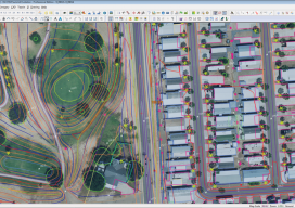
Aerial Mapping
Above: Fusion of data from multiple sensors is becoming a common request from geospatial users. Here, a 10cm RGB image was fused with a classified lidar point cloud that was collected at 25 ppsm. The resultant data provides users with an enhanced ability to support a wider array of applications than each dataset used discretely. New...
From Traditional Photogrammetry to UAS
Photogrammetry has changed substantially in the past three decades. When Jeff Yates began in the business 32 years ago, he used a projection system known as a Kelsh two-bucket plotter. “That was four generations ago of photogrammetric systems hardware,” he recalls. “From there, we went to the analog stereo plotter. That was the second big...
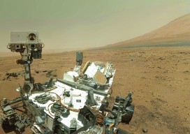
Cardinal Systems’ Extraterrestrial Photogrammetry
On Earth, photogrammetrists can normally use man-made objects in their frame—such as a road of known width or a curb of known height—as scales. When none is present, they can insert such “ground truth” as needed—for example, by placing onto surveyed locations targets that will be visible in their images. On other planets in our...