Tag Archives: QGIS
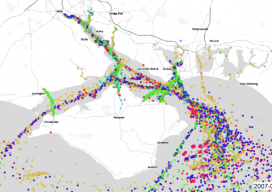
AIS: Using Shipping Data in GIS
We’ve all been dazzled by those awesome maps that animate ships or aircraft using AIS, as they move in near real time, but how do they work? What magic sits beneath the hood? As luck would have it, whilst working with the offshore wind farm industry I had to do a lot of vessel analysis,...
Virtualization: the Greatest Tool You Don’t (Currently) Use
This post is dedicated to a good friend, Chris Johnson, who, when we worked together a few years back, introduced me to this cool new word: VIRTUALIZATION. You see, Chris is an IT guru (see: enterprise systems architect)—a friend that every GIS guru should have so that you’ve got someone to pick up the pieces...
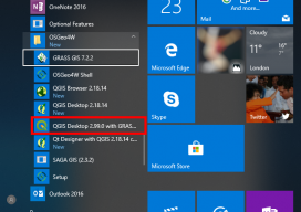
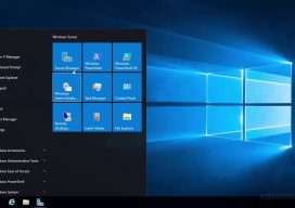
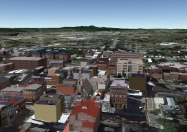
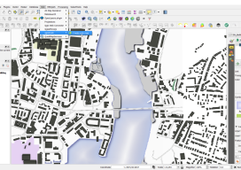
How to Use the New QGIS 3D
When QGIS revealed that they were going to add a 3D viewer, I was skeptical. Rumors were going around about it being a bolt on functionality and not really being fully adopted. To be perfectly honest, I was put off before there was anything to look at. As screenshots started to appear from Lutra Consulting,...

The Problem with GIS and Augmented, Virtual, and Mixed Reality
Over the last few years, altered realities technology has exploded, and now, with the introduction of Apple’s ARKit and Android’s ARCore, AR, MR, and VR are well within the reach of the non-developer. I can confirm this as I’ve created a few AR apps and MR apps myself over the last few months, with no experience...
Multipatches, Point Clouds and Meshes
A Guide to 3D GIS Data Formats Moving your GIS to 3D is a daunting task. Not only are there all the vertical issues to take into account, but also a whole new world of jargon, which can, at times, be quite overwhelming. In this post you’ll find a few of the data formats that...
Webmapping 3.5: A Recommendation for your First Step Into Web Mapping
It’s been almost a year since the web mapping series I did. Hopefully, by now, you’ve had a chance to have a little play with some of the options. If not, don’t worry, I have a sneaky confession to make… I held back on one option, QGIS2WEB, which is a wysiwyg plugin for QGIS. Why...