Tag Archives: robotics

xyHt Weekly News Recap: 09/30/2022
Teledyne and Seabed 2030 to Study Impacts of Volcanic Eruption in Tonga Greater St. Louis, Inc. Wins Esri Special Achievement in GIS Award Bluesky Takes to the Skies to Capture More Oblique Views of UK Cities Bentley, Genesys to Provide 3D Mapping Capabilities for Cities across India Free Webinar: What’s the Latest in Survey and...

Repositioning GIS
The technology that will drive the next era Esri calls GIS the nervous system of the planet, a platform relevant to almost every human endeavor. It’s a way to display, manipulate, and analyze geospatial data—and that ability is ever changing and expanding across industries. GIS technology allows us to derive location intelligence from spatial and...
xyHt Weekly News Links: 10/2/2020
U.S. Army Launching New PNT Office and Innovation LabGet a Drone on DemandGrants Support Robotics Research
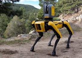
Coaching Robots
Continuous surveying (to support smart cities, infrastructure, geodesign, and construction) is opening expanded—but unconventional—roles for surveyors and geospatial practitioners. Photo above (added Nov 19th, 2019): A concept partnering Hilti, Trimble and Boston Dynamics on a walking platform, here shown with an X7 scanner (press release: prn.to/33XYbcJ). A member of your field crew that’s a bipedal, survey-rod-carrying...
xyHt Weekly News Links: 11/3/17
Garmin® acquires Navionics® SimActive Automates Direct Georeferencing GeoSLAM Launches Time & Cost Saving 3D Mobile Laser Scanners at Dallas Fall BIM Forum 2017 Singapore International Robo Expo Returns Bigger in 2017: Showcasing Latest Robotics Innovations USDOT launches Drone Integration Pilot Program Velodyne LiDAR and BoE Systems Partner for Integrated UAV-Borne LiDAR in Geospatial Data Collection
xyHt Weekly News Links: 4/21/17
RoboBusiness and TUS Expo Merger Launch of Global Robotics Events and Media Powerhouse Merrick Releases MARS(R) 2017 Software Suite Topcon introduces new GNSS receiver boardswith expanded constellation tracking