Tag Archives: SLAM
Introducing Exyn Nexys –
A modular mapping and surveying ecosystem that allows users to quickly capture highly accurate, colorized, real-time 3D point clouds in complex, dangerous, or inhospitable environments like those in the mining, AEC, and geospatial industries.

Built for Danger
While the operator stays safe, indoor drones carrying lidar and SLAM technology create a 3D map of the inside of hazardous spaces Nuclear power plants, ballast tanks, underground mines, toxic chemical plants, sewers, offshore oil storage, decommissioned industrial facilities—none of these are places suitable for humans; yet monitoring and inspection of the interiors are often...

xyHt Weekly News Links: 05/08/20
Qinertia, SBG Systems’ PPK software now supports third-party IMUs and offers a GNSS post-processing license covering all major GNSS receivers ASPRS Announces the 4th Edition of the Manual of Remote Sensing! Carlson Fixed Installation Scanner: Stationary Volumetric Scanner What Cloud Computing Means for Lidar in Construction How SLAM Technology Can Support New-build Projects Enhanced Exprodat...

Trends in Terrestrial Laser Scanning
Within the domain of lidar/remote sensing technologies, terrestrial laser scanning is currently the most widely adopted. Mapping drones have quickly become popular, but terrestrial laser scanning is used for more types of mapping and as-built survey applications. Other airborne (photogrammetry and lidar) and vehicle-mounted mobile scanning/mapping systems are also widely used, but there are far...
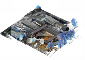
Handheld vs terrestrial lidar for building documentation
Sponsored by Paracosm Above: nmcn’s final CAD model as generated from PX-80 data. The 3D model is situated in the topographical point cloud data. Are these new tools accurate enough? Handheld mobile lidar scanners have gained market share in recent years by offering faster capture in GPS-denied indoor environments, easier documentation workflows for large, complex spaces,...

6D SLAM
An indoor spatial intelligence start-up from Germany is pushing the BIM industry forward through a combo of navigation and visualization. The line of people at the Intergeo Trade Fair in Frankfurt, Germany, waiting to get their hands on the NavVis M6 was long. Where everyone was on the lookout for the latest geospatial products on...