Tag Archives: Software

Taking care of Business
Kompass offers business a management solution built by surveyors
Software is a Service
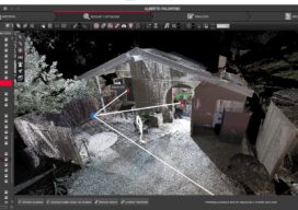
Transforming the Future with Reality Capture Software By Andreas Gerster Compared to software, reality capture hardware has traditionally attracted the lion’s share of attention. Lasers, robots, cameras, and UAVs breathe modernity and innovation. They are market disruptors, make for impressive photographs, and they are tangible. Ultimately, they are the very essence of the future. In...

Safety Underground
Prostar and KCI Technologies look beneath the surface to save time and money The devil is in the details of any construction project, but those involving work close to underground utilities can be the most dangerous. Nearly missing or even sometimes striking utility lines is a common occurrence across the nation and was a regular...

Luke Johnson
23 Young Geospatial Professionals to Watch in 2023 – 23 of 23 Name: Luke JohnsonCompany: Trimble, Inc. Current position: Technical Product ManagerAge: 27 Education: BS, Otago University, New Zealand After graduating, Johnson joined Trimble as an application specialist in 2018, testing and working on new features for Trimble Access, a survey field software. Wanting to immerse...
Derek Abernethy
23 Young Geospatial Professionals to Watch in 2023 – 10 of 23 Name: Derek AbernethyCompany: Trimble, Inc.Current position: Software product manager, vertical construction applicationsAge: 26 Education: BS in Engineering with honors, York University in Toronto, Ontario Abernethy’s work experience prior to entering the geospatial industry was in heavy civil and house construction where he...

Supporting Free and Open-Source Software
Free and open-source software (FOSS) is sweeping across the IT industry, everywhere from office programs (LibreOffice) to GIS software (QGIS, R, Python). It is also being used extensively by large companies such as Microsoft, IBM, Amazon, and Netflix for their internal services as well as being used as building blocks to offer services to clients. ...