Transforming the Future with Reality Capture Software
By Andreas Gerster
Compared to software, reality capture hardware has traditionally attracted the lion’s share of attention. Lasers, robots, cameras, and UAVs breathe modernity and innovation. They are market disruptors, make for impressive photographs, and they are tangible. Ultimately, they are the very essence of the future.
In recent years, the price of reality capture equipment such as terrestrial laser scanners has decreased significantly while performance and capabilities have improved. In the face of this changing technological landscape, the spotlight is rapidly moving to software, which is increasingly seen to have the potential to level up the hardware we have become accustomed to.
In addition, the turn to software is partly caused by the changing requirements of our communities and customers. As hardware has become less expensive, it has become more widely adopted in a range of industries, including, for example, forensic investigators at crime scenes. Not everyone now exposed to this technology needs or wants to be an expert in 3D laser scanning or data capture. Software technology puts new possibilities in the hands of people who might not have the qualifications or skills to operate a traditional static laser scanner. The democratisation of the hardware has enabled and, indeed, necessitated the development of an increased range of software capabilities.
An analogous hardware example is the camera. While some users may flourish when using a DSLR with interchangeable lenses and manual settings, others prefer taking a simple snapshot of a scene on their smartphone.
For data capture, thanks to software advancements, capturing 3D scans and bringing them to life as a digital twin is simpler than ever. Reality capture software already provides time-saving, cost-saving, and sustainability benefits in industries spanning surveying, construction, industrial manufacturing, and public safety. Software is a life-extending, value-add mechanism for its hardware counterpart. When taken together, software and hardware can enable teams to work together better, streamline workflows, and bring added value for customers.
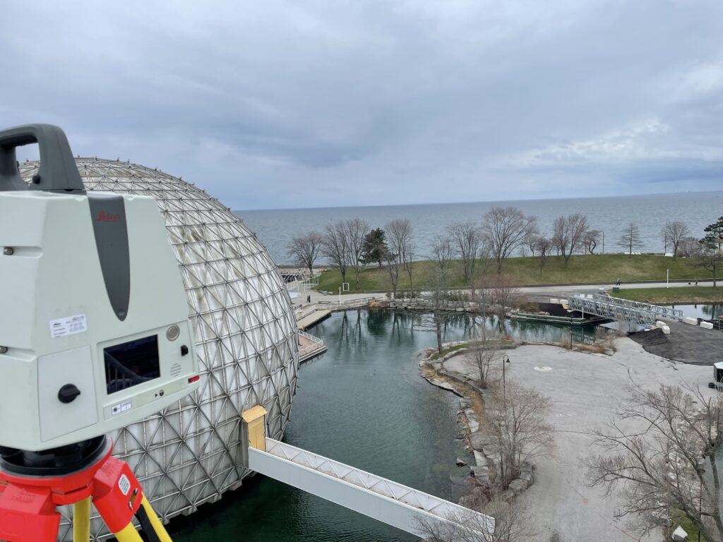
Surveying the redevelopment of Ontario Palace, Canada, with the Leica ScanStation. Image credit: 3DS Technologies
The value of software in the field
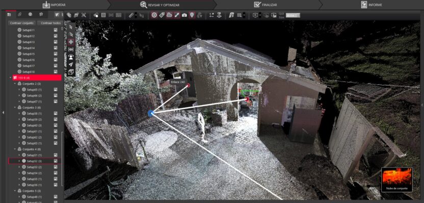
While software is often associated with backend, behind-the-scenes processes, it can have huge benefits for the teams on-site, not least because it tightens up every link in the workflow, making projects quicker to complete, less uncertain, and more efficient. In many cases, the site work for the surveyors and engineers is so demanding that they do not have the luxury of editing onsite, creating bundles, or preparing the data correctly. Reliable software gives an added layer of cushioning and flexibility, allowing the onsite team to continue scanning while the backend team starts cleaning the data.
Alberto Palomino, principal at DCMS, a company offering scan-to-BIM services for as-built documentation of existing buildings, described how “while the bells and whistles of the equipment on-site look amazing, it will be pointless if we don’t have the software in the office which can stitch the information together, edit it, and prepare it in different formats.”
One of DCMS’s recent projects at McGill University in Montreal, required the team to capture some elevations in very wet conditions. “We had a lot of issues with rain and with accessing elevation points, so we had to capture from unorthodox spots,” Palomino said. “But we were able to do it, knowing that in the background with Cyclone REGISTER 360, we would be able to stitch it all together, clean it up, and make sense out of it. The value of having a complete, consistent data set from the get-go, could be the difference between completing a project and walking away from it.”
Travis Sachs, COO of 3DS Technologies, another company based in North America working with high-resolution 3D laser scanning technologies, described how “having the iPad in the field, with the Cyclone FIELD 360 app, and being able to see what you captured, what you missed, and completing the pre-registration, it’s a game changer.
“For my first big job, a good day would be 34 scans at a time with pictures. And now, a good day for us is 170 scans. And that’s just in the field. The office time is also reduced, although I haven’t tracked that, I would estimate that we were spending around 20 hours before to around four now.”
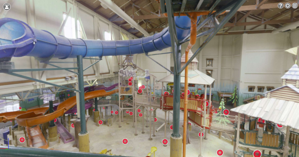
Water and amusement park design in Leica TruView to visualize every detail to identify areas that need attention. Image credit: 3DS Technologies
Protection and Sustainability to Heritage and Environment
Protecting and preserving our heritage, environment, and safety has become more crucial in a rapidly changing world. Reality capture software solves this challenge by allowing us to create digital twins that reside inside computers and control real-world processes from the comfort of our computers.
For sites of historical and cultural significance, reality capture has been priceless. Fortunately, Notre Dame Cathedral had been scanned before the devastating fire in 2019, creating a near-complete digital image. This enabled the rebuilding process to move forward more quickly and efficiently.
For safety and sustainability, reality capture technologies are being used to protect our communities and environments by identifying risks and monitoring change. In 2020, it enabled experts to detect and address safety concerns more effectively, as seen in the case of Höllentalklamm Bridge in the German Alps, where data analysis revealed hidden damage that could have led to catastrophic failure.
By monitoring the impacts of climate change on glaciers, we can take proactive action to protect our environment. Virtual Geographic Agency (Vigea) is a company which has undertaken a long-term topographical survey of the Gorner Glacier, the largest glacier in the Alpine region. With his team, co-founder Tomasso Santagata, embarked on an underground and underwater exploration to acquire data on the glacier’s health for climate change monitoring.
The team conducted the 3D scans inside the ice caves and produced 3D point clouds and 360-degree photographs. This is critical for monitoring climate change and to show the glacier’s evolution. The data processing is conducted using two software solutions, including Cyclone REGISTER, to create complete three-dimensional models of the interior and external environment. Researchers take this data to study the evolution of underground caves and look at the trend in temperatures and quantity of water drained into the glacier.
“Carrying out several surveys of the same caves at different times over the last two years, this has made it possible to carry out scientific comparisons, which gave the researchers involved the opportunity to study the evolution of the glacier,” Santagata said.
For the Gorner Glacier, the datasets and insights gained have informed how subsurface processes speed up the glacier’s demise. This provides crucial indications about its collapse over a considerably shorter time scale than current models predict. The data can be used to create 3D and 2D maps, virtual reality and interactive models, and scientific comparisons, bringing the Gorner Glacier’s risks into the public consciousness.
Software Is a Service
The capability of software to digest data and present it in different ways for different audiences and skill levels is a marketable asset. Travis from 3DS Technologies describes how “we want to bring 3D scanning to everybody: architects, engineers, constructors, so they don’t have to make huge investments. With the way things are evolving now, and with the software becoming more and more user-friendly, we’re finding that it’s becoming easier to help teams onboard their 3D scanning departments or divisions.”
He went on to say that it “provides instant visualisation in the field that’s critical for project success, because when you show a customer on-site, here’s what we’ve captured, they’’e like, ‘Wow.’”
Accessible reports mean that 3DS Technologies does not have to translate the data for its customers. They can look at the visual data and see immediately, in a heat map for example, if any issues require further investigation.
As the value of software has become more evident and software offerings have become increasingly reliable and error-resistant, an interesting trend has emerged whereby the software itself is viewed as a service.
Antonio Tomecich, marketing director and partner at DCMS, described how “more and more clients are relying on us for processing. We receive hundreds of point clouds from different clients in Europe. Our software helps us to clean up scans that we didn’t do.”
The Future is Built through a Smart Digital Reality™
Software can bridge the gap between what the real world looks like today on the one hand and a desirable, better version of our world on the other. This concept has been successfully applied in some verticals for many years. Enterprise Resource Planning (ERP) systems, for example, represent a “digital twin” of the financial status of a company or operation. Computer Integrated Manufacturing (CIM) is a concept where a digital object, or a CAD model, and an object in the real world, a manufactured artefact, are closely linked and remotely controlled.
In the coming years, software will allow people to turn to a new reality, one we like to call the Smart Digital Reality at Hexagon, the next phase after the digital twin. Smart Digital Reality is entirely data-driven, providing an experience that is immersive, rich, and engaging. It offers a complete line-of-sight to every situation in real-time with 360-degree context. This reality goes far beyond offering a static snapshot of truth by enabling real-time data capture and analysis and providing the freedom of autonomy. Autonomous technologies such as machine learning and AI enable the creation of systems that reduce and even eliminate the need for human intervention.
Reality capture software plays an increasingly vital role in protecting and sustaining our world. With the ongoing threat of climate change, the need for more sustainable and efficient practices in every area of our planet is urgent. And as we continue to face new and unpredictable challenges, whether natural disasters or a global pandemic, the ability to capture and analyse data accurately can be the difference between life and death.
 Andreas Gerster is vice president of reality capture software at Hexagon’s Geosystems division.