Tag Archives: SX10

Q&A with Trimble’s Ron Bisio
Bisio breaks down the as-a-service model, the rollout of the SX10, and smart infrastructure. We look for unfiltered insights from key folks in the geospatial industry, and the most recent INTERGEO exhibition and conference in Berlin was a prime opportunity to corner some of these folks for quick Q&As. One target was Ron Bisio, VP...
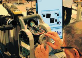
Behind the Big Eye of the SX10: Trimble, Danderyd, Sweden
A visit to Trimble’s engineering and production center in Danderyd, Sweden, reveals the story of the SX10’s development. As surveyors, we purchase and use some of the most sophisticated instruments of any field-oriented profession. Such sophistication yields incredible precision, accuracy, reliability, and flexibility, and, as would be expected, can carry hefty price tags. With such...
The Unthinkable and the Thinkable
The following is the editorial for the July print issue of xyHt magazine: If we completely dismiss a notion as unthinkable, we might find ourselves ill prepared should the notion become an eventuality. This applies to how we might view the status of our professions and how we fit into the markets we serve. Is...

xyHt News Links: 10/7/16
GeoSLAM (handheld laser scanning) and Blackdog Robotics (unmanned robotic vehicles)partner for remote surveying in hazardous environments/uneven terrain TerrAvion Launches First Aerial Imaging Solution Specifically Designed for Rangeland Trimble Changes Name to Reflect Company’s Technology Evolution Teledyne Optech to introduce new static and mobile surveying solutions at INTERGEO 2016 senseFly to Unveil new RTK/PPK-Ready, Large Coverage Mapping Drone at INTERGEO 2016...

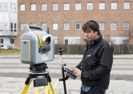
Trimble Unveils SX10 Scanning Total Station
Trimble unveiled a next-generation survey instrument—the Trimble® SX10 Scanning Total Station. It merges high-speed 3D scanning, enhanced Trimble VISION™ imaging technology and high-accuracy total station measurements into familiar field and office workflows for surveyors. The innovative solution provides surveyors and geospatial professionals with the capabilities and versatility to handle projects from traditional surveys to complex...