Tag Archives: Woolpert

Harnessing Drones the Photogrammetric Way
Above: The Inspire 2 drone, using a Zenmuse X7 sensor and 16mm lens, captured this high-resolution image of County Line Road in Beavercreek, Ohio. Credit: Woolpert. Considering that UAS are just another platform to carry sensors, new mappers should embrace merging photogrammetric techniques and practices with innovations by the computer-vision community to produce scientifically sound...
Open Source for Enterprise Solutions
A geospatial firm integrates open-source GIS and cloud services for the DoD’s IT security, a giant energy co-op managing 2,500 miles of transmission lines, and the USACE as they monitor dredging vessels. Too often, clients maintain outdated and inefficient workflows because they fear that building applications to improve processes would be too time-consuming and expensive....
Mapping the Pennsylvania Lake Erie Watershed
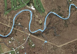
Imagery was collected along 77 miles of shoreline to provide a better understanding of Pennsylvania’s natural resources. By Brian Stevens The Pennsylvania Lake Erie Watershed is a substantial part of the world’s largest surface freshwater system, the North American Great Lakes. The watershed is 512 square miles, consisting of 15 major sub-watersheds. It’s estimated that...
Signs of Change
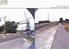
Above: This image, created with Woolpert’s online QC tool eQAS, illustrates the ability to review sign data from multiple perspectives and provides lidar and image data at the location of each sign. One collect, multiple uses. A mobile mapping system (MMS) is a versatile tool capable of creating both GIS asset inventories and design-level mapping...