
D. Ampatzidis, A. Tsimerikas, G. Moschopoulos, K. Balidakis and A. Mouratidis
EDITORIAL DISCLOSURE — The article is an editorial adaptation and professional-magazine presentation of research already published by the authors in the peer-reviewed Bulletin of Geophysics and Oceanography: Ampatzidis, D., Tsimerikas, A., Moschopoulos, G., Balidakis, K. and Mouratidis, A. (2025), “The alignment of PPP-derived coordinates to a local geodetic reference system through a reliable velocity field: case study in Greece,” Vol. 66, No. 1, pp. 43–56, doi: 10.4430/bgo00486. The present article does not claim new experimental results; it reframes and explains the previously published methodology and results for the broader GNSS engineering audience of xyHt.
Why PPP coordinates are not automatically local-datum coordinates
Precise Point Positioning (PPP) has changed the practical meaning of standalone GNSS positioning. A receiver can now determine centimetre-level coordinates without occupying a local reference station, provided that the observation period, data quality, products and processing strategy are adequate. Yet a PPP coordinate is not automatically a coordinate in the national datum used by a surveyor, cadastral agency or engineering project.
The fundamental issue is that modern GNSS positioning is expressed in a contemporary terrestrial reference frame, while many national mapping systems were established decades ago and are tied to a particular realization and reference epoch. Greece provides a clear example. The official Hellenic Geodetic Reference System of 1987 (HGRS1987) remains the national projected system used in many practical applications. HGRS1987 is connected to the Hellenic Terrestrial Reference System of 2007 (HTRS07), a densification of ETRS89 over Greece. The official transformation between HTRS07 and HGRS1987 has a nationwide RMS of about 8.3 cm and is fixed at epoch 2007.5.
This creates a deceptively simple problem. Suppose a surveyor obtains a PPP solution today. The resulting coordinates belong to an ITRF realization at the epoch of observation. The coordinates therefore describe a point in a reference frame that is itself moving relative to the older national realization. Simply applying a static transformation is not enough. The coordinate must first be related to the correct reference frame and epoch, and the motion of the site between epochs must be accounted for.
The practical message is important: in a deforming region, the velocity field is not a secondary correction. It is part of the transformation itself.
The Greek case is particularly demanding because the Aegean and surrounding regions exhibit strong and spatially variable tectonic deformation. A useful transformation therefore needs a velocity model that represents the three-dimensional motion of the crust and that can provide velocities not only at GNSS stations, but at arbitrary points where a user may have collected PPP observations.
The study presented here developed and tested such a workflow. Rather than proposing another seven-parameter transformation, the approach combines a spatially interpolated velocity field with successive reference-frame transformations and a final conversion to HGRS1987 projection coordinates.
A velocity field as the bridge between reference frames
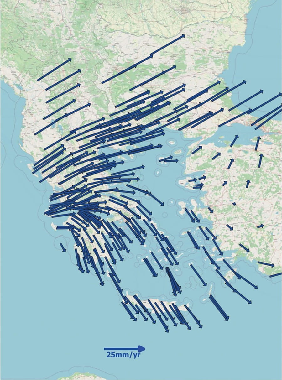
The first component of the workflow is a velocity model for Greece. The model was derived from the GPS velocity field published by Briole et al. (2021), which analysed GPS observations from 2000–2020. Their network contained 329 sites in Greece and neighbouring countries, with 282 stations in Greece. The velocities are expressed with respect to ITRF2014.
For the transformation problem, velocities are needed at arbitrary National Triangulation Network (NTN) benchmarks, not only at the stations from which the original velocity field was derived. The published study therefore used bilinear interpolation. Of the 329 available sites, 302 were selected to construct the interpolation model and 27 were retained as cross-validation sites. The stations were selected with attention to geographic distribution so that the validation would sample the country rather than a single tectonic environment.
The cross-validation results are encouraging. The RMS difference between predicted and official velocities was 0.6 mm/yr for the east component, 0.7 mm/yr for the north component, 1.0 mm/yr for the up component and 0.9 mm/yr for the horizontal component. Given the heterogeneous geodynamic behaviour of Greece and the unavoidable interpolation error, the authors considered these levels acceptable.
This is more than a statistical detail. A velocity model is being used to propagate coordinates from the observation epoch to the epoch at which the national transformation is defined. If the velocity field contains a systematic bias, that bias is accumulated into the transformed coordinates. Conversely, a sufficiently realistic velocity model allows PPP coordinates observed years apart to be compared consistently in the same local datum.
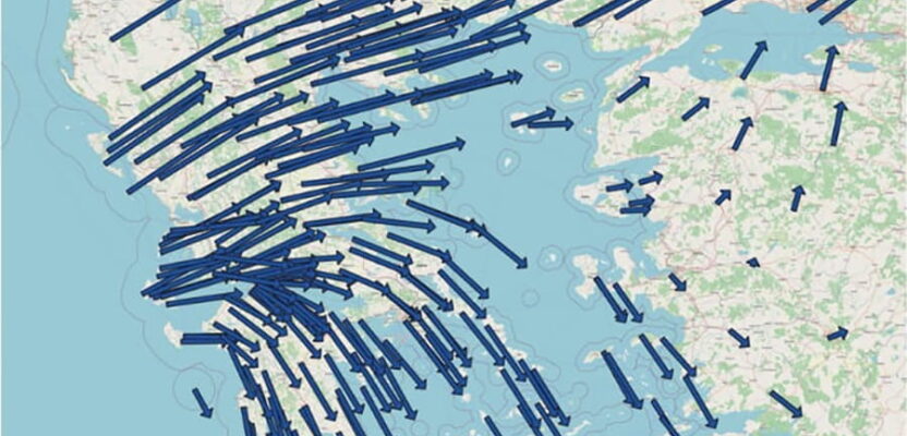
Figure 1 shows the horizontal velocity field used as the basis of the model. Its spatial variability is immediately apparent: the arrows do not form a single rigid motion, but change magnitude and direction across the Hellenic region. That behaviour is precisely why a single static transformation is inadequate for a rigorous PPP-to-local-datum workflow.
The three-stage transformation chain
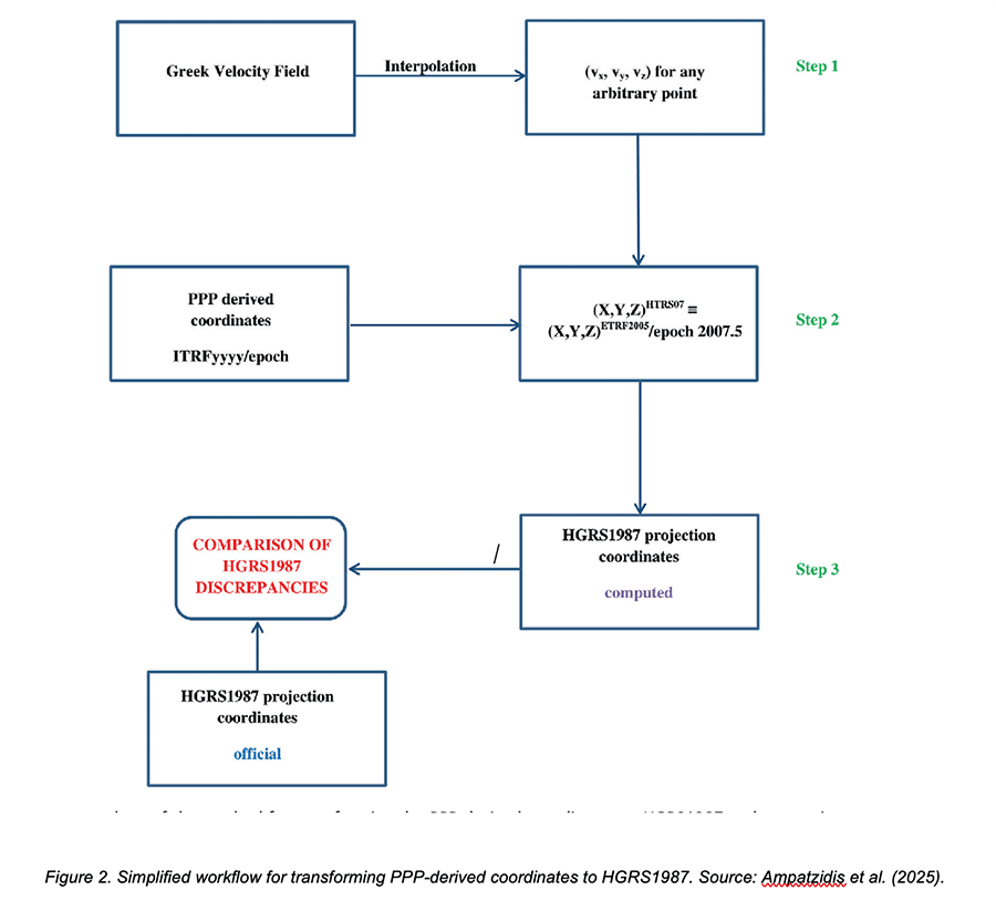
Once a velocity can be estimated at the point of interest, the transformation proceeds through three principal stages.
First, the PPP solution is expressed in the terrestrial reference frame associated with the PPP processing and at the epoch of observation. If that initial frame is not ITRF2014, the velocity information must be transformed consistently into ITRF2014, because the adopted Greek velocity field is defined in that frame.
Second, the coordinates are transformed to ETRF2005 at epoch 2007.5. This is the regional frame and epoch to which the Hellenic national transformation is connected. The published study used the EUREF ETRF/ITRF coordinate transformation tool for this step, supplying the starting reference frame, observation epoch, Cartesian PPP coordinates and the interpolated three-dimensional velocities.
Third, the resulting HTRS07 coordinates are converted to HGRS1987 projection coordinates. The Hellenic Cadastre HEPOS Transformation Tool was used for this final conversion. The analysis deliberately focused on easting and northing; the accuracy of the height transformation was not assessed.
The sequence matters. A user might be tempted to take the PPP latitude, longitude and ellipsoidal height and apply a local transformation directly. That shortcut mixes frame, epoch and datum effects. The workflow instead separates them so that each transformation has a clearly defined physical and geodetic meaning.
We also combined independent PPP solutions from CSRS-PPP and PRIDE PPP-AR. For each Cartesian coordinate component, the two solutions were weighted using the inverse of their component variances. The largest 3D Euclidean difference between the two software solutions at a point was 2.1 cm. In the context of the approximately 8.3 cm nationwide HTRS07-to-HGRS1987 transformation RMS, this difference was considered acceptable for the intended assessment.
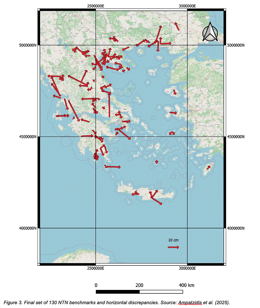
Figure 3 summarises the complete workflow. The velocity model supplies the motion information; the PPP solution supplies the coordinates at the observation epoch; the frame transformation carries the coordinates to the reference epoch; and the final national transformation produces HGRS1987 projection coordinates.
A nationwide test on the Greek National Triangulation Network
The methodology was evaluated using real GNSS observations collected at National Triangulation Network benchmarks. The data span a particularly long time interval: occupations were available from 2006 through 2023. The original dataset contained 141 benchmarks. Seven sites with occupation times shorter than 30 minutes were removed, leaving 134 sites for processing. Four additional benchmarks were subsequently rejected because their horizontal discrepancies exceeded 1 m and were considered unreliable. The final assessment therefore used 130 benchmarks.
The test network includes challenging geodynamic regions such as the Ionian Islands, Santorini, Crete and the Corinthian Gulf. This is valuable because a transformation that works only in relatively stable parts of the country would have limited practical value.
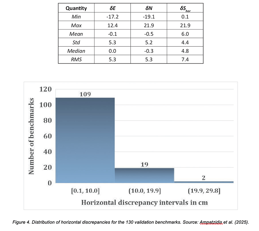
At each test point, the computed HGRS1987 easting and northing were compared with the officially published coordinates. The horizontal discrepancy was calculated from the differences in easting and northing. The resulting RMS was 7.4 cm.
That number deserves to be interpreted against the official benchmark for the national transformation. The published nationwide RMS for the HTRS07-to-HGRS1987 transformation is 8.3 cm. The PPP-based workflow therefore did not amplify the expected national transformation uncertainty; instead, its observed RMS was slightly lower.
The spatial distribution is also informative. Figure 5 shows the 130 test benchmarks and the corresponding horizontal discrepancy vectors. There is no obvious nationwide directional pattern. Importantly, the discrepancies do not appear to become systematically larger in the regions known for strong geodynamic activity.
The distribution is even clearer when the results are grouped by discrepancy magnitude. Of the 130 benchmarks, 109, or 83.2%, have discrepancies below 10 cm. Nineteen lie between 10 and 19.9 cm, while only two exceed 20 cm. The RMS of 7.4 cm is therefore not being produced by a uniformly large error across the network; rather, it reflects a distribution in which most sites are within 10 cm and a small number of larger discrepancies contribute to the overall statistic.
Does the method remain stable across epochs and occupation times?
Two practical questions are especially relevant to a GNSS practitioner. First, does the transformation become worse for observations made farther from the reference epoch 2007.5? Second, how long must a PPP receiver occupy a benchmark to obtain a reliable local-datum coordinate?
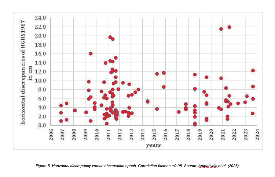
The first question was examined by comparing the horizontal HGRS1987 discrepancy with the observation epoch. The correlation coefficient was −0.05. In other words, the test did not reveal a meaningful relationship between the observation year and the horizontal discrepancy. This is an important indirect validation of the velocity model: if the velocities were systematically wrong, one would expect errors to grow with the time separation from the reference epoch.
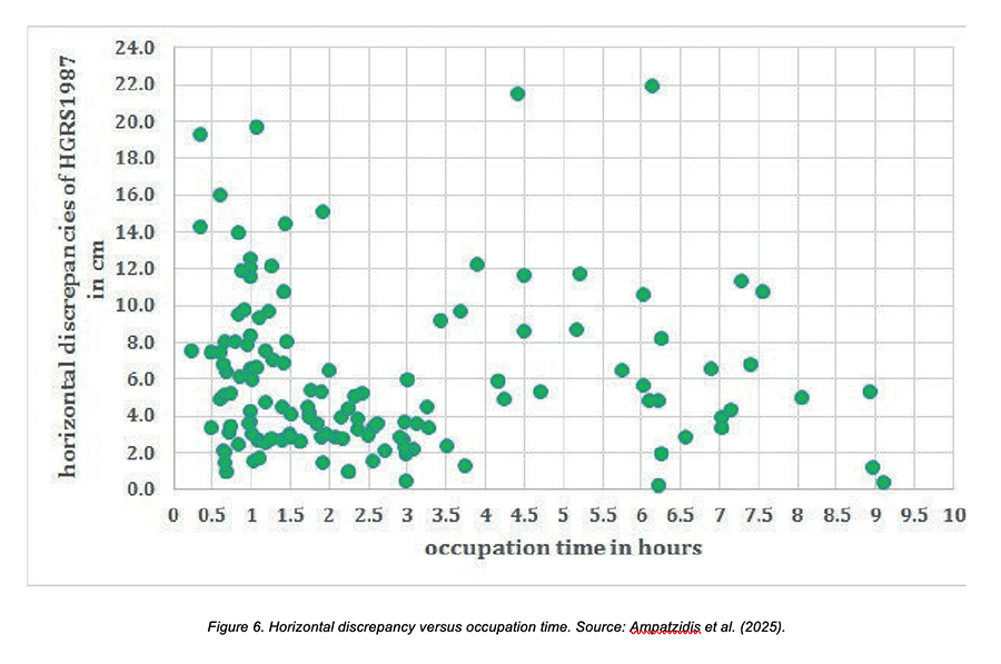
The second question was tested by comparing horizontal discrepancy with GNSS occupation time. The correlation coefficient was 0.05, again indicating no significant linear correlation over the tested dataset. However, the scatter plot shows substantially more variation among short occupations. The authors therefore recommend, conservatively, an occupation time of at least two hours when the objective is a reliable PPP-to-HGRS1987 conversion.
These two findings illustrate an important distinction between statistical correlation and operational guidance. The study does not claim that two hours is a universal PPP convergence threshold. Rather, two hours is a cautious recommendation for this particular transformation and dataset, intended to reduce the risk of unstable results associated with very short occupations.
Figure 7 shows the lack of an epoch-dependent trend, while Figure 8 illustrates the occupation-time relationship. Together they support the central practical conclusion: the transformation performance is governed primarily by the quality of the reference-frame/velocity treatment and the PPP solution, rather than by a simple linear dependence on observation year or occupation duration.
What this means for GNSS users—and for other legacy datums
The Greek experiment demonstrates a general principle that extends beyond HGRS1987. A national datum that was established at a specific epoch can remain useful for decades, but modern GNSS observations must be connected to it through a dynamic reference-frame concept.
For a practitioner, the workflow can be reduced to four questions:
- What terrestrial reference frame and epoch does my PPP solution represent?
- What velocity field is appropriate for the area of interest?
- What reference epoch defines the national or local transformation?
- Which official transformation should be used for the final projection coordinates?
If these questions are answered explicitly, the transformation becomes traceable. If they are ignored, a centimetre-level PPP coordinate can still be inconsistent with the coordinate system used by a national mapping or cadastral product.
The Greek results also show why external validation matters. The velocity model was not accepted merely because it looked physically plausible. It was evaluated at independent stations, then the complete PPP-to-local workflow was tested at 130 benchmarks distributed across the country. This separation between model construction and validation is a useful design principle for other national transformation systems.
The approach is also adaptable. The exact national frame, reference epoch, velocity field and projection will differ from country to country, but the logic remains the same: estimate or adopt a reliable velocity field, propagate coordinates consistently between epochs and frames, and only then apply the local datum transformation.
The original research concluded that additional NTN benchmarks should be occupied in specific regions under organised campaigns to verify that the transformation RMS remains at or below the 8.3-cm national level. For a future national reference-frame modernization, such campaigns would provide valuable independent evidence of how legacy coordinates relate to the current dynamic Earth.
The broader lesson is simple. PPP solves the problem of obtaining accurate coordinates in a modern terrestrial reference frame. It does not, by itself, solve the problem of making those coordinates compatible with every legacy national datum. Between the two lies time—and therefore deformation. A reliable velocity field is the bridge.
Short Bios
References
Altamimi, Z. (2005). ITRF2005 and consequences for ETRF2005. EUREF Symposium, London.
Altamimi, Z., Rebischung, P., Métivier, L. & Collilieux, X. (2016). ITRF2014: A new release of the International Terrestrial Reference Frame modeling nonlinear station motions. Journal of Geophysical Research: Solid Earth, 121, 6109–6131. doi:10.1002/2016JB013098.
Ampatzidis, D., Tsimerikas, A., Moschopoulos, G., Balidakis, K. & Mouratidis, A. (2025). The alignment of PPP-derived coordinates to a local geodetic reference system through a reliable velocity field: case study in Greece. Bulletin of Geophysics and Oceanography, 66(1), 43–56. doi:10.4430/bgo00486.
Bitharis, S., Ampatzidis, D. & Pikridas, C. (2017). An optimal geodetic dynamic reference frame realization for Greece: methodology and application. Annals of Geophysics, 60, S0221. doi:10.4401/ag-7292.
Briole, P., Ganas, A., Elias, P. & Dimitrov, D. (2021). The GPS velocity field of the Aegean. New observations, contribution of the earthquakes, crustal blocks model. Geophysical Journal International, 226, 468–492. doi:10.1093/gji/ggab089.
Bruyninx, C. (2023). ETRF/ITRF coordinate transformation tool. EUREF Permanent GNSS Network, Royal Observatory of Belgium. doi:10.24414/ROB-EUREF-ECTT.
Geng, J., Chen, X., Pan, Y., Mao, S., Li, C., Zhou, J. & Zhang, K. (2019). PRIDE PPP-AR: an open-source software for GPS PPP ambiguity resolution. GPS Solutions, 23, 91. doi:10.1007/s10291-019-0888-1.
Katsambalos, K., Kotsakis, C. & Gianniou, M. (2010). Hellenic Terrestrial Reference System 2007 (HTRS07): a regional realization of ETRS89 over Greece in support of HEPOS. Bollettino di Geodesia e Scienze Affini, LXIX, 329–347.
Kotsakis, C. & Katsambalos, K. (2008). The official transformation model between the reference system of HEPOS and the Hellenic Geodetic Reference System of 1987. Symposium, Aristotle University of Thessaloniki.
Tetreault, P., Kouba, J., Heroux, P. & Legree, P. (2005). CSRS-PPP: An internet service for GPS user access to the Canadian spatial reference frame. Geomatica, 59, 17–28.
Veis, G. (1995). Reference systems and the realization of the Hellenic Geodetic Reference System 1987. Technika Chronika, 2nd special edition, 16–22.
Zumberge, J.F., Heflin, M.B., Jefferson, D.C., Watkins, M.M. & Webb, F.H. (1997). Precise point positioning for the efficient and robust analysis of GPS data from large networks. Journal of Geophysical Research: Atmospheres, 102, 5005–5017. doi:10.1029/96JB03860.