All posts by Angie Duman

xyHt Weekly News Links: 8/4/17
Dewberry Honored for Special Achievement in GIS Reps. Westerman and Moulton Introduce Bipartisan Geospatial Data Act | Congressman Bruce Westerman GeoCue Announces GNSS Direct Geopositioning System for Low Cost DJI Drones Nearmap Provides High-Rez Oblique Imagery and 3D Products in Ready-to-Use Service ILMF Call for Papers Deadline is August 14! Congressman Doug Lamborn Addresses MAPPS...
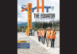
xyHt Magazine August 2017 Issue
To view this issue as it appears in full in print, click the cover: Below are featured articles from the issue on our website: Editorial Fire, Ice, and Latitude in Ecuador Nicholls State University Geomatics Program Photogrammetric Engineering at The National Polytechnic Institute Drones and Surveying Flood Zones Controlling the Future with Training Women in...
xyHt Weekly News Links: 7/28/17
INTERGEO – bridge to a digital future New Leica Captivate Pipeline application streamlines tracking and reporting Trimble introduces new Android app – Trimble Penmap – for field surveying and data collection ESA communication team hands off responsibility to GSA LizardTech optimizes Portfolio 2017 for geospatial data Icaros and TeAx Announce an Integrated Drone Mapping Solution...
xyHt Weekly News Recap: 7/21/17
Geneq’s NEW SXblue Platinum Survey Grade GNSS Receiver LizardTech and Extensis Optimize Digital Asset Management for Geospatial Data SmartNet North America expands full GNSS capability World’s Densest Urban Aerial Lidar Dataset Released Dewberry Hosts Fourth Survey Merit Badge Day
xyHt Weekly News Recap: 7/14/17
From the International Cartography Conference (ICC 2017) ‘Maps Are Alive’: Highlights from the Esri UC plenary
xyHt Weekly News Recap: 7/7/17
Tersus launches a ‘new generation’ NeoRTK system senseFly announces worry-free service package to keep professional drone operators flying Surveying the World of Tomorrow CompassCom to Release CompassTracker App for iOS & Windows Mobile Smart Phones at Esri User Conference Trimble Catalyst high-accuracy, on-demand geolocation service now available worldwide Quorum Launches myQuorum Land On Demand, Bringing Speed...