
A four-level ladder for handheld SLAM operators — and the training projects that climb it
The geospatial industry is buying handheld SLAM scanners faster than it is building the people who can run them. The instrument looks effortless, the live preview always shows something, and whether that something survives as a professional deliverable is decided by operator habits invisible to a bystander. Here is a practical, vendor-neutral competency ladder — and a first-90-days plan for a firm taking delivery of its first scanner.
By Peter Yang and Mark Chen
Every technology wave in surveying has had its skills lag. Total stations demanded new field procedures; GNSS demanded an understanding of datums, fix states, and multipath; UAVs demanded flight planning and photogrammetric judgment. Handheld scanning built on SLAM — simultaneous localization and mapping — is now repeating the pattern, with a twist that makes the lag more dangerous: anyone can walk through a building holding a scanner, and the screen will reward them with a point cloud. Whether the deliverable is any good is decided by things no bystander can see — where the scan was initialized, whether the doors were opened in advance, whether the loops actually overlapped, whether an RTK pseudo-fix went unnoticed under the trees.
In our support experience, the majority of “bad data” cases trace back to a handful of operator behaviors, not to hardware faults — and nothing about those behaviors is specific to one brand of scanner. That is actually good news. Behaviors can be trained, and trained quickly, if the organization knows what “competent” looks like at each stage.
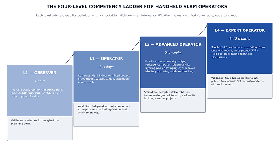
After several years of training dealers and field crews in many markets, our team settled on a four-level model (Figure 1). It is deliberately not tied to any product; the levels describe judgment, not button sequences. Firms adopting handheld SLAM — and the dealers supporting them — can use it to scope training, assign work, and answer the question we hear most often: “Is this crew ready for that job?”
Level 1 — Observer: one hour
An L1 can watch a scan being done, identify the major parts of the device — LiDAR, cameras, IMU, the GNSS antenna if fitted — and explain what a point cloud is. That is all, and that is enough for a purpose: an L1 knows what not to touch and why the operator keeps asking people to stand still. Validation is a verbal walk-through of the scanner’s parts.
Do not skip this level for managers and project leads. A one-hour exposure is what stops a project manager from promising a client “we’ll just wave the wand through the plant during the lunch rush.”
Level 2 — Operator: two to three days
An L2 can independently run a standard indoor or mixed indoor–outdoor project from start to deliverable, on a known site, without assistance. The curriculum that gets someone there reliably looks like this. Day one: assembly drills, a first dry scan, then a first live scan reviewed together in the processing software. Day two: the same known space scanned three times with different routes — comparing the three results teaches more about SLAM than any lecture — followed by a ground-control pickup drill. Day three: an independent project on a pre-surveyed site, with the deliverable checked against known truth.
That last step is the one that matters. “Within tolerance” is the phrase that separates training from familiarization, and it has to mean something concrete: independently surveyed check points, an RMSE computed against them in the manner the ASPRS positional accuracy standards describe, and a pass/fail against the tolerance the client contract actually specifies. An operator who has never had a deliverable checked against surveyed truth does not yet know whether their habits work.
Level 3 — Advanced Operator: two to four weeks
An L3 handles the scenes that make SLAM hard: forestry under canopy, tunnels and underground parking, ships and heritage interiors, multi-building campuses with repeated indoor–outdoor transitions. Crucially, an L3 can diagnose visually — recognize tilting, layering, and ghosting in a point cloud at a glance, name the likely cause, and recover most jobs through processing-mode switches and better route planning rather than blind re-scanning.
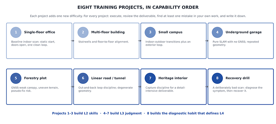
The path is one complex project per week, drawn from a deliberate mix: a tunnel or deep underground space, a canopy-heavy forestry plot, a campus with transitions, and a detail-intensive heritage or water-edge site. For each project the operator executes, reviews the deliverable, and — this is the discipline that builds judgment — identifies at least one mistake in their own work and documents it. A failure journal, re-read after ten entries, teaches pattern recognition faster than any manual.
Level 4 — Expert Operator: six to twelve months
An L4 can teach every level below, diagnose the root cause of any failure from the scan data and the processing report, write project SOPs, and represent the organization in customer-facing technical discussions. Validation is concrete: train at least two operators to L2, and publish at least two internal post-mortems of real project failures with root causes. An organization does not have an L4 because someone has used the scanner for a year; it has an L4 when failures stop being mysteries.
Why a ladder beats a workshop
Most scanner training today is a one-day vendor demo at handover — which produces, in this model’s terms, an enthusiastic L1 holding expensive equipment. The gap between that and L2 is where most bad deliverables, warranty disputes, and “the scanner drifts” complaints are born.
Three structural points make the ladder work. First, each level has a validation, not just a curriculum — a checkable output on a pre-surveyed site or a real project, so an internal certification means something. Second, the levels map to job assignment: an L2 should not be sent alone into a tunnel, and knowing that in advance is cheaper than learning it from the point cloud. Third, the model gives dealers and service providers a shared vocabulary. “We’ll staff this job with one L3 and one L2” is a statement both sides can price and verify.
There is a professional-responsibility angle too. In jurisdictions where a licensee certifies the deliverable, the ladder gives the licensed surveyor a defensible answer to “who ran the scanner, and how do you know they were competent?” — a question that is going to be asked more often as SLAM data finds its way into boundary-adjacent and as-built work.
Which raises the hiring question firms ask most: retrain a licensed surveyor, or hire a “scanning technician”? The ladder reframes it. L2 is a technician-level attainment reachable in days. L3 judgment — reading degenerate geometry, planning loops, managing control — is where a surveying background compounds fastest. The scarce resource is not people who can hold a scanner; it is people who can look at a wall that appears twice in a cloud and know, before opening a log file, which of four things they are looking at: a loop that never overlapped, an RTK anchor that was pseudo-fixed under canopy, a door that moved mid-scan, or a tracking break from a hand or strap across the aperture.
A first-90-days plan
For a firm taking delivery of its first handheld scanner this quarter, the ladder translates into a simple calendar. Week one: everyone who will ever be near the scanner gets the L1 hour; two chosen operators start the three-day L2 curriculum, ending with the validated project on a site the firm has already surveyed by conventional means — most firms have such a site in their archive, which makes the truth data free. Weeks two through eight: the two L2s alternate real production work with one stretch project per week from the L3 list (Figure 2), keeping a shared failure journal. By day ninety the firm has two operators approaching L3, a journal that doubles as an in-house operations manual, and — most valuable of all — an internal answer to “can we take this job?” that is based on validated capability rather than optimism. The scanner did not get better in those ninety days. The deliverables did.
Handheld SLAM is on its way to becoming as routine in field kits as GNSS rovers are today. The firms that get disproportionate value from it will not be the ones with the newest hardware. They will be the ones that treated operator competence as a deliverable of its own — defined it, trained it, and validated it, one level at a time.
“The industry is shipping handheld scanners faster than it is training the people who run them, and every bad point cloud that results gets blamed on the hardware — this ladder is how a firm closes that gap in ninety days.” – Peter Yang
About the Author
 Peter Yang is Product Manager at Tersus GNSS, where he is responsible for the company’s handheld SLAM scanner line and trains dealers and field crews worldwide. He is lead author of the open, vendor-neutral field guide Handheld LiDAR SLAM Guidance — From First Scan to Professional Deliverable (Tersus GNSS, 2026), from which this competency model is adapted.
 Mark Chen is Director of Digital Media at Tersus GNSS and a former Tersus product manager.
mark.chen@tersus-gnss.com