All posts by Boris Skopljak

What Can Spatial IT Do for You?
Helping firms meet the challenges of the global uptick in infrastructure development. Editor’s note: What is spatial IT? This umbrella term for the spatial component of the new wave of digital wizardry that’s transforming our geospatial and geomatics professions and industries can seem nebulous. xyHt has adopted the following working definition (as the term applies...

The Future of Office Software
Cloud-based computing offers advantages in speed and cost, and desktop software is adapting to leverage the benefits. It seems like just yesterday we had dial-up internet connections using 56k modems. It is amazing to observe how technology has evolved and how much our lives depend on being connected. That evolution is driving fundamental changes for...
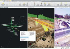
Geospatial Data United
Industry trends are moving toward consolidated environments for data visualization, processing, and management. From the title you might get the impression this article is about a soccer team. To geospatial professionals, however, the title phrase could describe an ideal situation—the ability to handle all geospatial data in a common software environment. A soccer team is made up...
Raising the Confidence Level
A surveyor’s most important deliverable emerges from detailed analysis and quality control. Recently, my four-year-old son grabbed my tape measure and began taking measurements of our living room. I asked if he wanted to be a surveyor like his dad, and he confirmed with a smile on his face. I played a small joke on...