All posts by Gavin Schrock

Cool Stuff Seen at HxGN LIVE 2018
Juergen Dold, president of Hexagon’s geosystems division, walked onstage to deliver his annual keynote at the 2018 HxGN LIVE conference and exhibition, toting a small school-sized backpack. During the course of the keynote he pulled two new products from the backpack. BLK3D The first was the BLK3D, a pocket-sized 3D measurement device built for rapid...
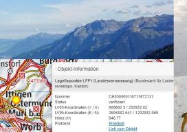
Surveyors Invited to Join Research Delegation
Land Surveyors and other geospatial professionals are being sought to join a delegation to Switzerland in September of 2018 to research models for cadastral systems. This is the first of an envisioned series of international delegations and exchanges seeking to foster a broader understanding of cadasters and cadastral systems within the surveying community. This is...

A Fine Line
Notes from a visit to the new production facility for Topcon and Sokkia optical surveying instruments. I asked Tsutomu Ishibashi, a production line technician at Topcon’s Yamagata manufacturing facility, what message he would like to convey to the surveyors who use the products he helps produce. His answer was, “We are always trying to improve,...

I-Shoku-Ju
A joint interview with Topcon president and CEO, Satoshi “Steve” Hirano, and Topcon Positioning Systems president and CEO, Ray O’Connor. I recently had an opportunity to sit down with Satoshi “Steve” Hirano, president and CEO of Topcon Corporation, for a candid interview at the company’s global headquarters (THQ) in Tokyo. The timing of this visit...

Epson Abides – New Wide Format Plotters for the Small Office
A New Series of Large-format Plotters for Small Businesses and Home Offices At the 2018 Esri User Conference and Exhibition, Epson announced a new line of T-Series large-format plotters that should appeal to small home/office needs for surveyors, engineers, architects, designers, and people working in schools and construction job shacks. Folks can plot out check...

Precisely Shot
Aerial imaging, GIS, and GNSS play a crucial role in the success of golf’s 2018 U.S. Open Championship. “Basically, we need to construct a small city—every year and in a different location,” said Timothy Lloyd, senior manager of U.S. Open operations at the United States Golf Association (USGA). Lloyd’s team is charged with planning and...