Category Archives: Aerial/UAS

Using Lidar to Strengthen Ground Control
With the maturity of aerial photogrammetry in the early 1900s in pre-war Germany, military applications, especially reconnaissance and semi-accurate 3D maps and approximate contour lines, became the norm.

GIS Implementation in Construction: Techniques and Benefits
With Aspectum mapping software, construction companies can model objects down to the finest details and monitor project development from start to finish.

senseFly Expands its Line of Fixed-Wing Mapping Drones
A mapping drone in the $10,000 price range might sound like one of those things that’s too good to be true. And up until now, maybe it was. A Swiss company called senseFly, a global leader in fixed-wing mapping drones, has expanded its flagship eBee X drone solution with the launch of eBee Geo. The...
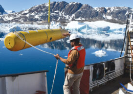
AUVs: Crucial to Seafloor Mapping Effort
In 1775, in Saybrook, Connecticut, the brothers David and Ezra Bushnell built Turtle, a little egg-shaped wooden submarine held together by iron straps, with a 30-minute air supply. The next year, in New York Harbor, Turtle engaged in the first naval battle in history involving a submarine. The first autonomous underwater vehicles (AUVs), undersea systems...

MAPPS 2020 Geospatial Excellence Awards
MAPPS honored members with the 2020 Geospatial Excellence Awards as part of the organization’s 14th annual Awards Presentation that took place January 26, 2021. The event was hosted by Riegl USA in conjunction with the 2021 winter meeting in Orlando, Florida. The Geospatial Excellence Awards are presented to regular and associate member firms whose entries...

iPhone Pro 12 – Survey device??
There is a buzz on the underground, geospatial people are tweeting about lidar in the new iPhone 12 Pro. What really escalated it all was Matterport releasing a new scan app on the Apple store, it was then followed by a few geospatial people alluding to be able to scan cities and even map rooms...