In 1775, in Saybrook, Connecticut, the brothers David and Ezra Bushnell built Turtle, a little egg-shaped wooden submarine held together by iron straps, with a 30-minute air supply. The next year, in New York Harbor, Turtle engaged in the first naval battle in history involving a submarine.
The first autonomous underwater vehicles (AUVs), undersea systems containing their own power and controlling themselves while accomplishing a pre-defined task, were torpedoes, first used in battle in the late 1800s. The development of modern AUVs began in the late 1950s, for data gathering, but did not emerge as a mature market with many commercial products until the first decade of this century.
With the development of more advanced processing capabilities and high-yield power supplies, AUVs are now being used for an increasing number of tasks and missions. For example, the oil and gas industry uses AUVs to make detailed maps of the seafloor in preparation for building subsea infrastructure, which is much cheaper and more efficient than with traditional bathymetric surveys, as well as to inspect pipelines and other underwater man-made structures.
AUVs are also used for environmental assessment, search and rescue, harbor and coastal surveillance and protection, mine detection, and a wide range of other governmental, commercial, and scientific tasks.
Mapping Earth’s Oceans
Oceans cover more than two thirds of Earth’s surface. Yet, due to the extreme conditions facing exploration, the majority of the world’s ocean floor is still unmapped. Additionally, most surveying efforts focus on busier, shallow waters for the purpose of safety of navigation. The overall shape of the global ocean floor is an estimation based on satellite altimetry and interpolation between sparse acoustic measurements.
Therefore, a key activity in oceanography is to map the seafloor and study its structure and character. Sonars mounted on the hulls of ships or towed by them can map the seafloor at high resolution in shallow water. In typical ocean depths, however, they are unable to show in detail such seafloor features as lava flows or slumps.
Doing so requires underwater platforms equipped with high-frequency sonars. The problem is that sea water attenuates high frequencies. Therefore, to map at high resolution, the sonar needs to be as close as possible to the bottom. In the past, this has been done using submersibles or towed systems.
However, the former are expensive and erratic and the latter are slow, can be dangerous near rough seafloors, and produce data that is hard to accurately geolocate. For these reasons, now that AUVs are highly reliable and have long endurance, they are the preferred option to collect very high-quality data sets, especially in the deep ocean.
In very shallow waters, unmanned surface vessels (USV) are used for bathymetry where manned vessels cannot operate due to their greater draft (the vertical distance from the waterline to the lowest point of the hull or attachments, such as propellers and rudders, thus the minimum depth of water in which a vessel can float). USVs were originally created by retrofitting previously manned craft with radio controls.
Now, a wide variety of purpose-built USVs are available. Because they do not require space for a crew, USVs can be outfitted with more sensors and equipment than a manned craft of equivalent size—including sonar, imaging systems, radar, ISR systems, environmental sensors and dataloggers, weapons payloads, or even a small AUV.
Current examples of AUVs and USVs for bathymetry include the following:
YSI’s Ecomapper, which can be deployed by a single person, collects bathymetric data using a single-frequency sidescan sonar. It can operate up to a depth of 100 meters and georeferences its data using WAAS-corrected GPS when it surfaces. It features a Doppler Velocity Log (DVL) to increase its underwater navigation accuracy. Potential applications include baseline environmental mapping in freshwater, estuarine or near-coastal environments, bathymetric mapping, dissolved oxygen studies, event monitoring, non-point source studies, point-source dispersion mapping, security, search and rescue, inspection, shallow water mapping, thermal dissipation mapping of cooling outfalls, and trace-dye studies.
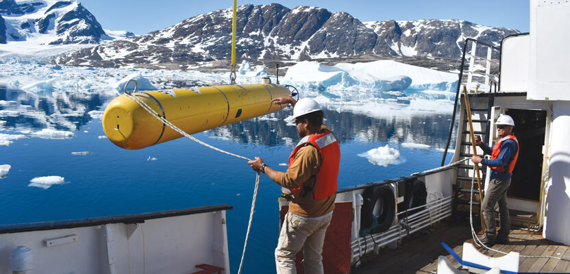
The Dorado-class AUV developed by the Monterey Bay Aquarium Research Institute (MBARI) is optimized for meter-scale mapping of the seafloor. It is equipped with a swath multibeam sonar, two sidescan sonars, and a sub-bottom profiler that all operate simultaneously during a mission. The sub-bottom profiler enables the detection of layers within the seabed sediments, faults, and depth to the basement rock. All the components are rated to a depth of 6,000 meters. To detect and map the underwater structure of icebergs, MBARI has also developed an AUV configuration with a multibeam sonar and scanning sonars oriented sideways.
The HUGIN AUV, built by Kongsberg, is used worldwide by scientific institutions, survey companies, and navies. It is remotely configured, controlled, monitored, and maintained, highly maneuverable and stable, and rated, like MBARI’s, to operate at depths of up to 6,000 meters. Its batteries enable it to operate for up to 100 hours at four knots, which means that it can cover up to 740 kilometers. Its typical payload includes a synthetic aperture radar (SAR) or a side-scan sonar, a multibeam echo sounder, a sub-bottom profiler, a camera, a CTD, and a volume search sonar. The payload software controls and displays data from sensors in real time, allowing for assessment of sensors functionality at a global remote desktop location via satellite link.
The REMUS 6000, designed under a cooperative program involving the Naval Oceanographic Office, the Office of Naval Research, and the Woods Hole Oceanographic Institution, operates in depths ranging from 25 meters to 6,000 meters, allowing for a wide range of autonomous operations. It can be used for numerous exploration and mapping purposes, including hydrographic surveys, environmental monitoring, debris field mapping, search and salvage operations, and scientific sampling and mapping.
Teledyne Marine’s Oceanscience Z-Boats are USVs designed specifically for hydrographic surveyors, as well as for land surveyors who need to complete inshore hydrographic work. They have deployed acoustic Doppler current profilers, water quality monitoring instruments, and echo sounders in lakes, rivers, and coastal environments.
Other manufacturers of USVs include iXblue, Seafloor Systems, Hydronalix, Oceanalpha, and L3Harris.