Category Archives: Aerial/UAS

xyHt Weekly News Recap: 07/16/2021
Esri Releases New Predictive 2050 Global Land Cover Map Esri Awards GIS Users for Innovations Velodyne Lidar Partners with NVIDIA Metropolis for Infrastructure Solutions Zoom75 & Zoom 95 – The New GeoMax Robotic Total Stations Lidar Helps Reveal Radiation Hot Spots at Chernobyl GIS-Pro 2021: October 3-6, 2021 Setting the Record Straight: The RETAIN Act...
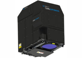
CZMIL SuperNova is Changing Bathymetric Lidar
CZMIL SuperNova, Teledyne Optech’s next generation bathymetric lidar system, is changing the way information about coastal territory is collected and processed. Terratec AS, a leading Norwegian mapping firm, is the first private company to acquire the CZMIL SuperNova and the only company in the EU to engage in work around environmental change and coastal zone mapping...

Taking Flight
As drones begin to fill our airspace, Switzerland is figuring out how the skies will remain friendly

Aerial Efficiency
With 174 miles of transmission line to capture and the need for fine detail images for inspection analysis, SkySkopes turned to a helicopter platform with a 100-megapixel (MP) camera to produce RGB photographs for quick project turnarounds.

Drones in Confinement
From warehouses to underground facilities, demand for drone inspections in GPS-denied places is rising. The new flying destination for UAVs is the great indoors.

Ingenuity Breaks New Ground for UAVs – on Mars
NASA’s Ingenuity Mars Helicopter continues to set records, flying faster and farther on Sunday, April 25, 2021 than in any tests it went through on Earth. The helicopter took off at 4:31 a.m. EDT (1:31 a.m. PDT), or 12:33 p.m. local Mars time, rising 16 feet (5 meters) – the same altitude as its second flight....