By Artem Berehovyi
Sponsored Content
It’s become simpler than ever to build in modern cities. Paper charts and maps have sunk into oblivion with the march of technology – and especially thanks to Geographic Information System (GIS). Applying innovative GIS approaches and techniques, companies can model objects down to the finest details and monitor project development from start to finish.
So, what role does GIS play in the construction industry?
GIS and Its Benefits
GIS mapping software embraces a computer-based system for gathering, checking, storing and providing spatial data. For years, this technology has played a major role in the global geospatial market, and is currently known for robust solutions that are applicable in various spheres. GIS not only ensures accuracy and data integrity, but also allows for accelerating building and road development, as well as minimizing any negative impacts on the environment.
For real estate developers, GIS serves as an effective tool for planning, managing and monitoring construction activities. With analytics algorithms, it’s possible to perform basic analysis and switch between app and desktop without losing even a bit of information. In addition, widgets assist in customizing the user experience so that histograms and other charts can be added and updated as needed.
Step Back in History
Many may think that GIS is a relatively new technology. However, the first computerized maps appeared in Canada in the 1960s. They were used for land resource planning. In the 1970s, the technology was commercialized and demonstrated its effectiveness in numerous fields worldwide. Later on, GIS evolved and allowed for accessing an immense volume of geographic data. But how is mapping software applied nowadays for infrastructure development?
Constructing with GIS
According to a United Nations projection, 68% of the world’s population is expected to dwell in urban areas by 2050. This means that current urban development trends will likely accelerate. Luckily, GIS solutions, like Aspectum, can come in handy at all stages of the construction process.
Pre-Building Stage
When planning the construction of any object (a road, a factory, or anything else), GIS can facilitate precise site assessment. Developers can receive complex information about the area and determine whether it fits the building – for example, to assess natural risks such as floods or tectonic activity, as well as take measures to mitigate possible disaster outcomes. With this in mind, Aspectum GIS allows fast, data-driven decision-making since managers can calculate expenses and eliminate possible risks when building or exploiting the object.
Monitoring Progress
Satellite imagery, as a critical element of mapping software, helps to track the build process from the outside. Up-to-date information can be compared and analyzed with previous data to keep an eye on every small site. After that, it can be shared with other team members for quick updates and decision-making. Using GIS cloud-based software in construction prevents delay and frittered away budgets.
Specifically, satellite monitoring allows developers to control budgets when constructing large urban objects or infrastructure facilities. Based on visualized data, managers can analyze the costs of all work and compare invoices with actual expenses without missing a thing.
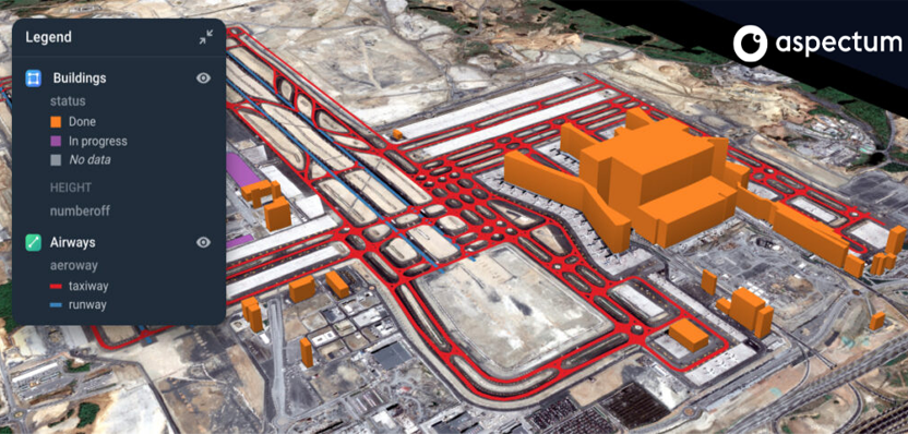
Here is a great example – construction of Istanbul Airport. Aspectum showcases the efficiency of its multifunctional in-built tools in a case study of the Istanbul Airport construction. This analysis of the world’s largest airport was done using Aspectum’s Change Detection feature. With satellite and drone imagery, the Aspectum team created Digital Twins of the objects and visualized multi-layered transportation infrastructure to track changes. At this point, mapping software has significantly simplified monitoring and assisted in reaching efficiency at every stage of object development.
Tendencies in GIS
Obviously, the construction industry has access to numerous advantages of GIS integration since developers can significantly optimize and enhance a single object or even city construction. This means that savvy developers will want to stay state-of-the-art, one of Aspectum’s key draws.The company’s functionality and expertise provide precise multi-layered visualizations based on IoT solutions.
Cloud-based Software
The use of a cloud-based software system fosters communication and operation processes both in the field and office. Everyone with access can monitor the building, at anyplace and anytime. Specialists can easily access required documents, add new bits of information, edit or modify significant data.
Digital Twins
This technology enables specialists to optimize processes and considerably boost productivity by creating a holistic digital model of the future building. With a digital duplicate, there are more chances to predict possible risks, while still at the office and thus overcome them in the field. Digital twins ensure data-driven decision-making at all stages of construction.
Drones
Drones are a relatively new, yet widely used, technological solution in construction. They allow for the collection of geospatial data and transmitting aerial insights to mapping centers. With drones, developers can enhance building progress and track emerging problems beforehand.
Suffice to say, current trends in GIS tackle numerous tasks – from data visualization to processing. With satellite and drone imagery analysis, users can receive a complex picture of the build process and monitor changes one step at a time, as well as sort, store, and get fast access to historical data in Analytical Widgets.
What the Future Holds
Plenty of modern cities are about to become the cities of the future. However, this transformation would hardly be possible without advanced technologies such as mapping software. Thanks to the potential of that software, the growth of cities is expected to accelerate in the years to come. And while no one can fully anticipate these changes, it’s evident that many of them will be connected with the use of GIS tools – as their applications and capabilities will only grow.
Find us here:
Facebook: https://www.facebook.com/Aspectumapp
Twitter: https://twitter.com/Aspectumapp
Linkedin: https://www.linkedin.com/company/aspectumapp