Category Archives: Cartography
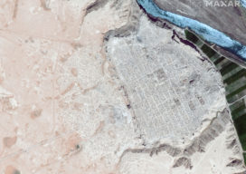
Antiquities Trafficking and the Surveyor: How Mapping is Keeping History Public
Conflicts around the world are often funded by the sale of drugs, guns, diamonds, ivory, and antiquities. Often these cultural relics stolen from home countries are purchased unwittingly abroad. One organization is hard at work to alert buyers and the art market about this growing problem, using maps to broadcast the stories of missing artifacts....
Using QGIS in the Cloud with Amazon Web Services (AWS)
It’s easy to run a popular open-source geospatial suite on this hosted cloud platform: AWS. QGIS is a great piece of software, and I would really recommend you try it out if you are currently working with ArcGIS, MapInfo or any other piece of GIS software. However, if you don’t have admin rights on your...
SLAM, Bam, Thank You Ma’am: Giving Preservation a Hand(held)
Handheld SLAM mapping technology helps preserve historical sites for future generations. Across the world, places of historical significance are regularly monitored to ensure they are cared for properly and preserved for future generations. This care and attention can help us learn more about our past and inform design and building projects of the future. When...

Twinning Pau: Multi-Platform 3D for a Royal City
Helicopter, UAS, and terrestrial data give the ancient city of Pau a modern 3D “twin.” Featured image: Cities around the world are seeking “digital twins” to plan, analyze, operate and design. Pau, France, is on the cutting edge with its 3D model (mesh). On the right of these images is the actual city. On the...

Another Curveball: Coronavirus and Geospatial
Out of the blue, we’re facing another curveball. The current global concern (COVID-19, aka the Coronavirus) was generally not anticipated, and the situation changes daily. It was hoped that, by the time this is published, the situation would have calmed dramatically—but sadly it has taken a turn for the worse. Thus far disruptions have only...
Outlook 2020’s 40 Under 40
The following is xyHt’s 2020 collection of 40 under 40: profiles of motivated and accomplished young professionals under 40 years of age. Click on each name to view their profiles below. Kwabena Obeng Asiam Researcher & Lecturer – Leibniz University Published PhD candidate in land administration; FIG Young Surveyors Ghana Evaluating the evidence and making...