Category Archives: Cartography

Jack Dangermond Interview Part 1: The Company
At the Esri User Conference, xyHt European editor Nicholas Duggan sat down for a one-on-one interview with Jack Dangermond, Esri founder and CEO. In Duggan’s five-part online series, running each day this week, Dangermond discusses everything from Esri’s beginning to the future of GIS. Here in Part 1 the two discuss Dangermond’s company. Nicholas Duggan:...
George Washington, Surveyor
If what you know about George Washington comes from your primary and secondary education— —Then John Berlau’s new book George Washington, Entrepreneur (St. Martin’s Publishing Group, $28.99) holds a treasure trove of information for you—especially for surveyors. Our US education tells us Washington was a great military leader, a diplomatic statesman, and a political pragmatist,...
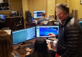
Army Corps’ (JALBTCX) data improves coastal projects
In a hotel conference room on Long Island, New York, a team of experts is processing data and information on computers. Alongside them is a large display monitor that is projecting the information. The team is the Joint Airborne Lidar Bathymetry Technical Center of Expertise (JALBTCX). “It’s a beautiful thing. On the screen they are...

Galapagos in 360 Degrees
“Like cinders… infernal… leafless…” Charles Darwin wrote those words in his diary on September 16, 1835, after setting foot for the first time on the Galapagos. Darwin, whose scientific work in the far-flung archipelago considerably changed our understanding of how life on Earth evolves, was a keen observer of nature. And on that day, while...

Citation (Jet) Needed: A Start-Up Takes Off
A wealthy investor on the other end of the line said, “Juan, I understand you are photogrammetrist and a pilot. Are you ready for a challenge? I bought six Citation jets in a government auction, and I want you to help me turn them into a modern aerial photography platform.” For those of us who...

xyHt Weekly News Links 7/17/2020
*Click here to visit xyHt’s Virtual Trade Show* Congress Moves Against FCC’s Ligado Decision Bad Elf Flex™ Adopts the Hemisphere Phantom™ Module Honeywell Refines Navigation Revealing the World from Satellites Common Ground Alliance Launches New Expo