Category Archives: Cartography

All Hands on Deck
Mapping the entire U.S. seafloor is an epic task. The country’s new national hydrographer says it can be achieved by coordinating efforts and using the latest technology.

MAPPS 2020 Geospatial Excellence Awards
MAPPS honored members with the 2020 Geospatial Excellence Awards as part of the organization’s 14th annual Awards Presentation that took place January 26, 2021. The event was hosted by Riegl USA in conjunction with the 2021 winter meeting in Orlando, Florida. The Geospatial Excellence Awards are presented to regular and associate member firms whose entries...
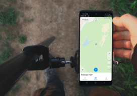
ReachView 3: Native App for Reach Receivers
ReachView 3 is the all-new mobile app by Emlid for working with Reach RTK receivers. Familiar point collection and stakeout tools are now powered with the new user interface, coordinate system support, and ability to manage big projects. ReachView 3 is a free app available for Android and iOS devices. Coordinate Systems on Board: In ReachView...

Survey Says: Height of Mount Everest is Two Feet More
Since 1856 China and Nepal have argued over the actual height of Mount Everest, the world’s tallest mountain that sits on the border between the two countries in the Himalaya Mountains. Until today (December 8, 2020), Nepal has measured Everest at 29,029 feet. That counts the ice cap on top of the actual height of...

Digital Coast Act Becomes Law This Week
The Digital Coast Act, now approved by both chambers of Congress, will become law this week, and that is a significant step toward expanding and making accessible geospatial data to support environmental and economic development activities in the coastal regions of the United States. The bill creates a program within the National Oceanic and Atmospheric...

Doers: Christoph Hinte
Christoph Hinte on 25 years at Intergeo Christoph Hinte is the organizer of INTERGEO, the world’s biggest annual geospatial trade fair and conference. As CEO of HINTE Expo & Conference, he has been involved in the development and strategy of INTERGEO events since in 1995. Hinte tells xyHt why this year’s event, October 13 to...