Category Archives: GNSS/Location Tech

A Better GNSS?
With America, Russia, China, and the EU all now having GNSS constellations operating, what does it mean for surveyors and geospatial professionals?

xyHt Weekly News Recap: 07/16/2021
Esri Releases New Predictive 2050 Global Land Cover Map Esri Awards GIS Users for Innovations Velodyne Lidar Partners with NVIDIA Metropolis for Infrastructure Solutions Zoom75 & Zoom 95 – The New GeoMax Robotic Total Stations Lidar Helps Reveal Radiation Hot Spots at Chernobyl GIS-Pro 2021: October 3-6, 2021 Setting the Record Straight: The RETAIN Act...

Remote Monitoring
Keeping tabs on assets with wireless monitors is not just for those dirty, dangerous or distant jobs

Why the NSRS and SPCS are being Modernized
Modernization of the National Spatial Reference System (NSRS) is driving the adoption of the State Plane Coordinate System of 2022 (SPCS2022). This is big news for surveyors because 48 states already have a codified SPCS.
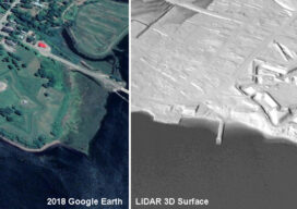
Lidar, 3D Modeling Bringing Fort Anne Back to Life
A Canadian archaeologist is using advanced mapping and visualization technologies to bring one of the earliest European settlements in North America back to life. Dr. Jonathan Fowler combined a centuries-old map with a modern 3D terrain model to portray Fort Anne and its surrounding in stunning detail – just as the Nova Scotia site looked...

Using Lidar to Strengthen Ground Control
With the maturity of aerial photogrammetry in the early 1900s in pre-war Germany, military applications, especially reconnaissance and semi-accurate 3D maps and approximate contour lines, became the norm.