Category Archives: GNSS/Location Tech
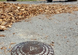
Are HARNs on Death Row?
In the late 1980s, the National Geodetic Survey (NGS) launched a program, in cooperation with State partners, to establish a High Accuracy Reference Network (HARN) across the United States. HARN’s History With the rapidly increasing availability and use of GPS equipment, NGS recognized the need to establish a network of high-accuracy, passive survey monuments with...
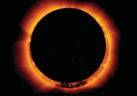
Night in the Afternoon: A US Solar Eclipse
What you need to know about the 2017 solar eclipse The upcoming solar eclipse will leave a 70-mile-wide trail of darkness across the United States on August 21, 2017 (see the map of the eclipse path on pages 44-45). This will be a once-in-a-lifetime event for many people. While another total solar eclipse will make...
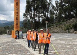
Fire, Ice, and Latitude in Ecuador
A team of U.S. surveyors visited Ecuador to use real-time PPP to pay homage to the 18th-century “Geodesic Mission to the Equator,” one of the most difficult and significant missions in the history of surveying and geodesy. Pictured above: The team of U.S. surveyors on the 2017 Ecuador visit (from back to front): Rich Leu, John...
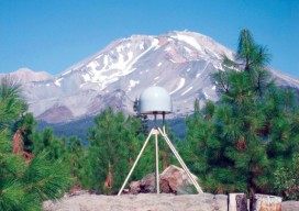
Geodetic Control over Time and Space in California
Interview with Scott Martin, Chief of Geodetic Control and GNSS Surveys, California DoT Above: UNAVCO/PBO station P655 with Mt. Shasta in the background. Matteo Luccio: Scott, what is your relevant background and what is your current role? Scott Martin: I’m a state employee with the California Department of Transportation (Caltrans), in the Office of Land...
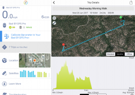
A Good Day with a Bad Elf
It was a beautiful early summer day, ideal weather to take a road trip to the Pike National Forest about an hour from my Eastern Colorado home. Pike National Forest comprises 1,106,604 acres southwest of Denver and is a frequent haunt of mine for camping, off-roading, and in past years dirt biking and ATV-ing. This...
Shifting Ground: USGS on Earth Movement after an Earthquake
Ken Hudnut, science advisor for risk reduction, US Geological Survey, talks GPS and earthquakes. Editor’s note: In many ways, we are all participants in a grand scientific endeavor that’s on the cusp of helping humankind prepare for some of the most destructive natural hazards–earthquakes and volcanic eruptions. The fields of seismology, geodesy, and surveying have...