Category Archives: GNSS/Location Tech

Launch of INTERGEO 2017: Topics that get the geo-IT sector noticed
Berlin, 16 May 2017 3, 2, 1 and lift-off. The 2017 INTERGEO season is underway, with a programme fully reflecting its long-standing key focus – “Knowledge and action for planet Earth”. Once again in 2017, the leading international trade fair for geodesy, geoinformation and land management’s hot topics will highlight ground-breaking developments and projects of...

GEO Business 2017
Nicholas makes the annual pilgrimage to GEO Business for xyHt This blog is going to start with a short piece about skips. If you are afraid of skips (skips are what you’d call “dumpsters” across the Atlantic), turn away now …. Monday morning and 24 hrs from the start of GEO Business 2017, I get...
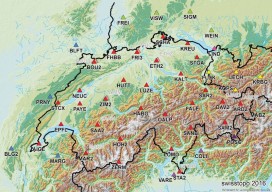
GNSS Network SWIPOS Continues to Lead the Field(s)
One of the oldest and most successful real-time GNSS networks continues to lead in providing precision and reliability for surveying, mapping, geodesy, science, and more. By Gavin Schrock, PLS In the early 2000s, when the first RTN were being introduced in North America, network developers would rely on the experience of their peers in Europe...

Remote Sensing in Yellowstone Park
A consortium demonstrates the value of integrated remote-sensing technologies for studying and monitoring the impacts of climate change using the northern range of Yellowstone National Park as a testing area. By Dr. Olaf Niemann, Dr. Robert Crabtree, and David Brown In 2014, a consortium between environmental scientists and an airborne remote-sensing company was awarded funding...
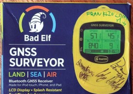
First Stop for Wandering Elf STEM Education
Franklin Community High School, Indiana First Stop: Franklin Community High School, Indiana xyHt, in conjunction with GNSS solutions provider Bad Elf, has kicked off an interesting STEM project that seeks to promote the physics and geodetic science behind GNSS. A Bad Elf GNSS Surveyor (a Bluetooth peripheral receiver for smartphones and tablets) has begun its...

Will You Be Replaced by a Robot?
It’s difficult to open a magazine or look at a news site on the internet and not run across the “robots are going to take your job” theme. So, I’ve been doing a bit of reading on the subject, and I’ve come up with some very basic criteria for determining if your job may be...