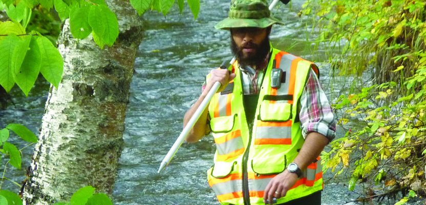
Above: Matt Santiago, current UAA geomatics student, is perfecting his surveying technique in the “classroom,” i.e. the South Fork of Chester Creek on UAA’s campus.
The University of Alaska, Anchorage’s Geomatics Department continues to grow and place all its students in jobs at graduation.
Matt Santiago arrived in Alaska wearing Air Force blue. When he removed his uniform a couple years later, he took a long look at himself and made some decisions about the future.
His first decision: Alaska was the right place for him and his family. Matt went to Alaska at somebody else’s command, but he quickly fell in love with the mountains, with the crisp air, with the caribou and bears. The prospect of leaving this seemingly endless landscape to return to the heat and humidity of his hometown in Florida held very little appeal. No, Alaska was for him.
His second decision? Get a degree in geomatics from the University of Alaska, Anchorage.
Before joining the Air Force, Matt had spent a year and a half on a surveying crew in the Everglades. Even today, his expression brightens when he talks about this experience. Trekking through swamp and mud. Joking around with his coworkers. Learning the ins and outs of unfamiliar techniques and technology. Solving problems. These aspects of that first surveying gig lingered with him for more than a decade.
Now he’s nearly finished with a B.S. in geomatics and, like many other UAA geomatics students, he already has a job in the profession, traveling all over Alaska for the Department of Transportation, creating new memories out in the field.
So, what is it about UAA geomatics that attracted Matt Santiago?
UAA Geomatics
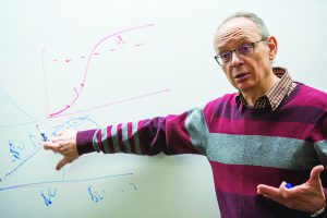
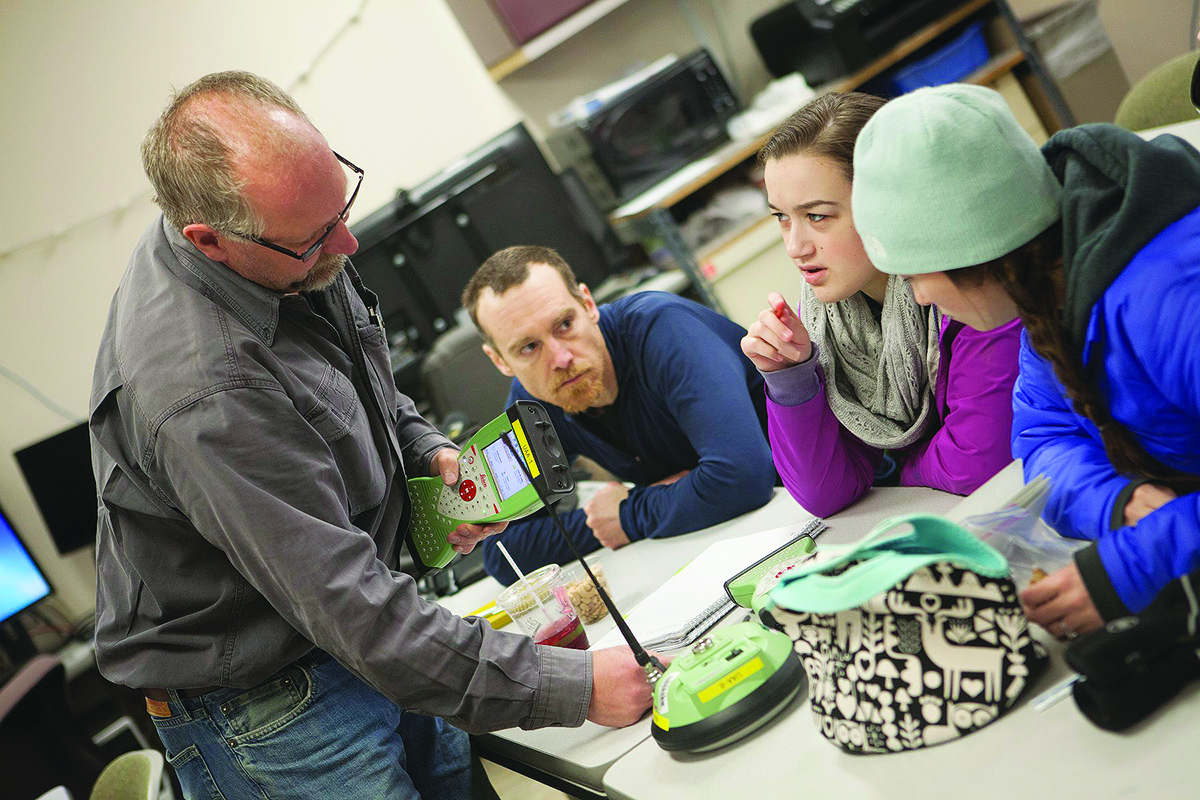
To a group of research assistants, Prof. Gennady Gienko explains key concepts regarding the development of a snow load map for Alaska. Credit: James Evans, UAA.
The Department of Geomatics at UAA knows its importance to the state of Alaska. A wide swath of industry leaders work closely with the department to ensure that students are molded into competent professionals. Graduates walk away from campus and into the job market with skills that set them up for success in not only land surveying and development, but also in transportation, medicine, the defense industry, environmental assessment, public safety, and business. In Alaska, this means ample employment opportunities in the oil industry, state and federal agencies, the military, and Alaska Native Corporations. (If you’re reading this in the Lower 48 and you’re not familiar with Alaska Native Corporations, it’s worth a Wikipedia visit.)
In fact, Matt is not alone in finding a career-oriented job before graduation. Professor Gennady Gienko, who has been a member of the UAA Geomatics Department for over a decade, is willing to bet that 100% of his students are gainfully employed by the time ink dries on their diplomas. Internships with ConocoPhillips or summer jobs at the Bureau of Land Management often develop into full-blown careers.
Gienko credits the employability of his students to the close relationships that the Geomatics Department retains with industry leaders.
“We have companies from around the world right here in Anchorage, Alaska,” said Gienko. “Big companies and small companies, alike. They help us develop the program to maximize the usefulness of our graduates. And not just that. Companies have donated a lot of time and money and equipment to UAA to make us a top-tier program—datasets, software, hardware, just about anything we need.”
With two-year and four-year degree options, the geomatics program is flexible. The two-year degree provides a broad base of understanding, equipping students for technician-level jobs, while the four-year degree provides depth and specialization in one of three emphasis areas: surveying, geospatial science, and geo-development.
Each emphasis prepares students for different types of careers. The surveying emphasis, for example, requires students to take a first-aid course, because professional surveyors in Alaska and around the globe must battle against the elements in unforgiving situations.
On the other hand, the geospatial and geo-development concentrations both require three courses with the word “analysis” in their titles—Point Cloud Analysis, Spatial Analysis, and Image Analysis. No matter which concentration a student chooses, they can expect to gain expertise in advanced geomatics techniques and technologies such as photogrammetry, geodesy, and remote sensing.
With about 20 graduates per year, the geomatics program at UAA is one of the largest in the country. For Isaiah Ditmer, a lidar surveyor and UAA alum from the class of 2010, the number of graduates churned out by UAA is great—because the industry needs fresh minds and bodies—but that’s not what makes UAA special.
“It’s the breadth of the program, really,” he said. “I’ve worked with and supervised graduates from other universities, but inevitably they have more fundamentals to learn than UAA people. Since most professionals end up working with data or tech from a lot of geospatial fields, not just our specialties, UAA grads start with a leg up. They’re already familiar with how all the pieces fit together.”
Isaiah’s right. UAA has one of the few programs that provides instruction in all six major areas of geomatics identified by the Accreditation Board for Engineering and Technology.
Moving Online
The Geomatics Department at UAA is working to become even more flexible. They are in the second year of a four-year plan to move the entire program online. Professor Jeff Hollingsworth, chair of the department, has been leading the charge.
“The original intent of the idea was to serve rural Alaska,” he said. “There’s a lot of need in those parts of the state that aren’t connected to the road system, so there’s opportunity for locals to step up, get their degrees, and get good jobs, all without forcing them to uproot their lives and relocate to Anchorage.”
As a consequence of this desire to serve all Alaskans, the program’s reach has expanded beyond the state’s borders, as out-of-state students are also able to attend class from the comfort of their homes.
“So far, only a few out-of-staters have taken the plunge,” said Jeff, “but we’re confident that that number will continue to grow as we fine-tune the program.”
One of the largest difficulties of moving online may not come as a surprise. The study of geomatics, particularly the sub-discipline of surveying, is very hands on. UAA’s traditional, in-person students are frequently spotted in the woods surrounding campus, lugging around equipment, shouting out coordinates, getting mud on their boots—gaining a feel for the actual work of surveying.
Solving this problem in the short term has required UAA to mobilize its professional network. In just about any community in Alaska, UAA geomatics has a connection to a local company, and UAA is leveraging those connections to get surveying equipment into the hands of their online students.
“It’s not a perfect solution,” Jeff said. “I’m the first to admit that. Our connections have been great, and we couldn’t express our gratitude enough, but this isn’t a long-term fix.”
After toying around with a few ideas, the Geomatics Department has settled on what it thinks will work best, both for the lifestyles of online students and the quality of their education. The faculty would like to more fully separate the lab components of their online courses—the hands-on stuff—from the lecture components.
During the school year, online students will be able to participate in real-time lectures and seminars through a web portal called Blackboard Collaborate, and the lab components will be taught in-person in Anchorage during a weeklong intensive program. Once or twice per year, online students will travel to Anchorage for a week and spend eight hours per day getting a handle on the technology and techniques that employers will expect them to know.
“The fact of the matter is that surveying and the whole field of geomatics is a staple profession,” said Jeff. “Society needs surveyors—and competent surveyors. We want to make the online program as convenient as possible, but our students need to hold the technology in their hands. You can’t learn that from a lecture alone.”
“Besides,” Jeff added, “Who wouldn’t enjoy spending a week up in Alaska?”
The Faculty
The Geomatics Department counts itself lucky to have a set of four full-time faculty members with diverse skill sets and backgrounds. Some are hardcore academics, others are down-to-earth professionals-turned-professors. Their interests range from the seemingly mundane to truly out-of-this-world science. Here is a quick introduction.
Jeff Hollingsworth
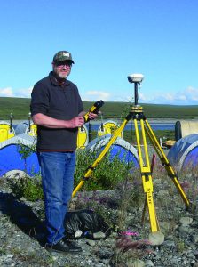
Out in the field, Prof. Jeff Hollingsworth sets up surveying equipment.
When professor Jeff Hollingsworth was 17 years old, he thought he might make a career out of panning for gold. Jeff’s father didn’t think that was such a hot idea, though, so he sat his son down and gave him a few options to choose from. Of the choices, surveying didn’t seem that bad. At least it would mean working outside a lot of the time.
Fast forward a couple decades, and Jeff had become the owner of a successful surveying firm. He ran that company from 1986 to 2011 when he played around with the idea of retirement. Relaxation, however, isn’t something Jeff was built for. He picked up a teaching job at Penn State and then, after a semester, he moved his life to Alaska to join UAA’s Geomatics Department. These days, he serves as the department chair.
“It’s all about the students,” he said. “They infuse this whole place with energy. I get the opportunity to share 30 years of surveying experience with these people, and then they go off and start their own journeys. What’s not to love?”
The irony of it all is that finally after all these years, Jeff got to pan for gold in the Last Frontier.
Caixia Wang
“UAA students are a special bunch,” said professor Caixia Wang. “They all work hard, many with full-time jobs, needing that paycheck to support themselves, but also looking to their futures. Fostering their interest in geomatics and helping them succeed is absolutely my passion.”
Caixia’s full-hearted belief in UAA students expresses itself in several ways. Whether she’s teaching an introductory course like Principles of Mapping or an advanced course like Spatial Information Analysis and Modeling, she gives it her all.
But for Caixia, learning goes beyond the classroom. She has made it a point to include students in her research projects. Recently, she has worked with undergrads on two projects. The first is to develop fast, inexpensive methods to measure shallow water using satellites, which can give a leg up to state and federal agencies responding to floods.
The second is to quantify changes on the land’s surface in Alaska’s oil-rich North Slope using synthetic-aperture radar, which could affect the oil industry’s ability to make rational decisions concerning land use. She believes these projects could set her students up for a lifetime career in geomatics.
Caixia said, “When I look at these students, I am encouraged every single day.”
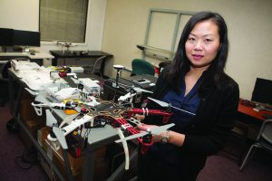
Prof. Caixia Wang shows off a drone that she has used in various research projects. Credit: Phillip Hall, UAA.
John Bean
“I spent seven years as a structural analyst before getting into surveying,” said professor John Bean. “But, hey, I figured surveying just looked like more fun!” Born in New Hampshire, John began his professional career out east, but he couldn’t stop himself from moving west, seeking wilderness and adventure. Eventually, he hit the coastline, but he still wasn’t satisfied. North seemed like it might be as good a direction as west, and he eventually ended up in Alaska.
In 2009, he started at UAA. Most days you can spot him wandering around the campus’s trails and streams, with a line of orange-vested students following him. Those students are convinced that one of these years, John is going to race in the Iditarod—the 1,000 mile sled dog race. When this came up in conversation, John said, “No, they’re just fooling. I don’t think I could’ve asked for a better job, teaching these guys and gals. They’re all great. Oh, but I do own three sled dogs.”
Apart from working with students, the highlight of John’s time with UAA has been the chance to travel to remote locations in Alaska for surveying work in support of Arctic research. Out there, John feels like he’s found the wilderness he was always looking for.
Prof. John Bean helps a group of students to understand new material. Credit: Phillip Hall, UAA.
Professor Gennady Gienko is one of those people who sees the world in an inch of coastline. No, really—that’s not just poetics. He creates high-resolution 3D models of the Point Woronzof bluff on the west side of Anchorage in order to explore the dynamics of coastal erosion. These 3D models are accurate down to less than an inch, and those inches add up to answer big questions about the relationship between land, water, and air.
But that’s only one of Gennady’s many research interests. He is in collaboration with scientists in three different continents on a dizzying array of projects. He uses geostatistical analysis to learn about the presence of uranium in Ukrainian groundwater, he uses spatiotemporal analysis to learn about tropical cyclones and their effects on coasts around the globe, he uses photogrammetry to reconstruct Native Alaskan masks found in anthropological expeditions—and he even builds 3D models of Enceladus, an ice-encrusted moon in orbit around Saturn.
“I’m a curious person,” he likes to say. Clearly, he’s not wrong. From an inch of coastline in what is practically his own backyard to an icy moon drifting through space 1.2 billion kilometers away, Gennady is a man in search of curiosities.
A Way Forward
A little more than a decade ago, the UAA Geomatics Department graduated an average of five or so students per year, many of its classes were taught out of a glorified shack, and the faculty engaged in little to no research. Now, there are more than 20 graduates per year, the department has lots of dedicated classroom space in addition to a large laboratory, and its faculty members regularly publish in top geomatics journals.
This growth is thanks largely to the labor of these four full-time faculty members who all came to UAA within a couple years of each other. With the online program still in its infancy, it looks as though UAA has a lot more room to tackle new challenges and continue to grow.
But that’s what geomatics professionals are all about, as current UAA student Matt Santiago knows full well.
He said, “At the end of the day, it’s all about problem-solving. That’s what they teach us in these classes. Sure, we learn some very specific techniques, some very specific tech, but underlying it all is an elementary skill—the ability to solve problems.”