Category Archives: GNSS/Location Tech
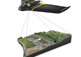
UAS Surveying without GCPs
The subject of applying direct georeferencing to UAS platforms was a recurrent theme at the 2016 Commercial UAV Expo last week. Direct georeferencing offers the possibility of mapping without the use of ground control points, providing UAS operators a significant advantage in terms of speed. As an example of this technology, we reached out to...

Just Call Me Charlie
A Conversation with GPS and Technology Pioneer Charlie Trimble Click here to view a downloadable PDF of “Charlie Trimble Interview” When asked what the key was to his successes, Charlie Trimble, the co-founder of the global geospatial and navigation company that bears his name, thought for a moment and came up with: “I had a...

The Green Monsters of GPavin
An interview with the director of the GPS Directorate Col. Steven P. Whitney recently answered questions about the mission of the directorate, and he debunked a popular myth about the GPS constellation. Colonel Steven Whitney is the director of the Global Positioning Systems (GPS) Directorate at the Space and Missile Systems Center, Air Force Space...

Carlson’s BRx5 Receiver: the Birth of a New Instrument
Carlson Software & Hemisphere GNSS Bring a Lightweight Receiver to Market For land surveyors and others in careers that rely on constant use of GPS and GNSS technology, not to mention the millions of consumers with receivers in their smart phones, it is easy to forget that instant location remains technologically miraculous, relying as it...
Surveyors of Tomorrow: GIS and Families
Over the past few years, I’ve been gathering quotes and anecdotes—from the kids of survey practitioners—about what they think other kids might find attractive about their parent’s chosen profession and why they might (or might not) choose the same path. Here’s a sampling that represents what I hear. The three children of Brad O, the...
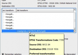
Using OSTN15 with QGIS
As you may be aware, the United Kingdom has a new transformation model that is OSTN15. But why? What does it mean to the geospatial community? Without being too nerdy, tectonic plate movement means that the “model” surface (the geoid) is slowly moving away from being the best fit for the coordinate system. It has...