
Category Archives: GNSS/Location Tech
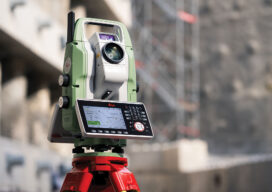
The Essential Instrument Gets Smarter
Just when you thought there was nothing new in the world of Total Stations… Appearances can be deceptive. If you’re thinking that this is just another total station, you might be pleasantly surprised by the following look under the hood. But why a new total station? Didn’t the technology of such instruments peak in the...

Fixposition’s Vision-RTK Pro + Esri Is a Game Changer
The streets of modern cities are lined with glass and steel, forests close their canopy around remote infrastructure projects, and construction zones sprawl across bridges, tunnels, and high-rise footprints. These are not exceptions but the everyday environments in which surveyors and mapping professionals work. Yet in these very settings, the bedrock of their craft—centimeter-level GNSS...

GIS Needs Geodesy
Why Accuracy Matters Now More Than Ever When I entered university to study geodesy in 1976, graduating students had begun their studies with slide rules and thick algorithm books. Pocket calculators were nonexistent, and electronic distance measurement (EDM) devices were heavy, delicate, and cumbersome. No satellite positioning systems were yet available. At that time, the...

How Lidar Is Helping Cattle Farmers Make Smarter Land Use Decisions
In the rolling hills and rugged terrain of Spain, a quiet revolution is underway, one that’s helping cattle farmers make better decisions about how they use their land. At the heart of it is lidar, a remote sensing technology that’s proving to be more than just a tool for mapping landscapes. It’s becoming a critical...

Oriented Imagery in GIS: Unlocking Value From Unstructured Data
In an era defined by explosive data growth and rapidly expanding drone-based sensing, the geospatial community faces a new frontier: unlocking the value of unstructured imagery. Chad Lopez, a solutions engineer with Esri’s Imagery and Remote Sensing team, is at the forefront of this effort. In a recent interview, Lopez discussed how oriented imagery—raw photos...

GNSS Backup at the Atomic Level
A first-of-its-kind GNSS backup system provides independent navigation solutions using quantum magnetometry. This is a double-plus development. Not only is it a solution that dramatically outperforms certain other GNSS backup approaches, but it is a prime example of a solution that leverages quantum sensing. It is compact enough, light enough, and has a power consumption...