Category Archives: GNSS/Location Tech

Why Opus Projects? Part 2 of 2
OPUS Projects Streamlines Submitting GPS Surveys to National Geodetic Survey By Philippe Hensel with Dan Gillins, Dan Martin and Julie Prusky “Texas Special Reference Center (TSRC) of Conrad Blucher Institute is leading the efforts toward modernization of the horizontal and vertical datums in the State of Texas, particularly in the subsidence zone in southeast Texas....
Why Opus Projects? Part 1 of 2
Part 1 of 2The new version of the NGS suite of Online Position User Service tools simplifies many tasks By Philippe HenselWith Dan Gillins, Dan Martin and Julie Prusky NOAA’s National Geodetic Survey (NGS) continues to improve its suite of Online Position User Service (OPUS) tools. In addition to single-point processing, OPUS offers a web-based...

What’s Inside Your GNSS Rover? Part 1
The venerable GNSS rover, has evolved into an essential part of a surveyor’s toolkit, although some mystery remains as to what that magic box does and how it does it. To demystify this, we engaged GNSS engineers to help craft this three-part “explainer” series. Part one The work of a surveyor requires a lot of...
HAS Potential
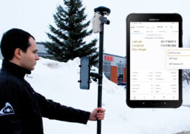
Free and Global: The new high accuracy positioning service (HAS) of the Galileo constellation and its advantages for GIS and asset mapping If you consider field mapping applications, such as for GIS, asset inventory and management, and field operations for utilities, how wonderful would it be to have sub-foot positioning in real time, with no...

The Advantages of “Built Here”
There are reasons other than policy and security to consider domestically produced drones. Yes, when it comes to the drone market there is an almost “default” choice. Having established dominance, it further benefits from price by volume. And then they can invest more in R&D from the increased profits—if they choose to and do not...

Sustainable Rainwater Treatment for the Future
How machine-control solutions are increasing efficiencies on ground-breaking projects by up to 60 percent The seaside town of Køge lies just forty minutes south of Copenhagen in Denmark. A rapidly expanding area, new housing projects and transport infrastructure are an immediate priority for residents and local authorities.But, for a town located just three meters above...