Category Archives: GNSS/Location Tech

An Exemplary Real-Time GNSS Network
For more than 20 years, SWEPOS has consistently demonstrated the full potential of real-time GNSS networks Standing in the main control center of Sweden’s real time GNSS network (RTN) system, I feel like I could be standing in NASA Mission Control. A marvel of infrastructure created by Lantmäteriet, the country’s mapping agency, the center has...

Refining Measurement
A land surveyor unpacks the concept of accuracy “Accuracy is addictive,” my friend David Doyle once said. Doyle is a geodesist by trade. For someone in his line of work, this addiction has a rich tradition. Geodesy is the study of Earth’s shape, rotation, and gravity field. The discipline involves an eternal quest to refine...

General Data Protection Regulation and the Locus Charter
Helping geospatial professionals to work ethically with location data Responsible data use is key to many professionals, not just in the geo and location industries. Data and privacy has been on our radar for a number of years now, and in recent years it has come to the forefront with the advent of General Data...
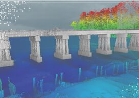
Teledyne Forms New Geospatial Company
Teledyne Optech and Teledyne CARIS have united to form the new Teledyne Geospatial, offering holistic solutions to seamlessly map land and sea through the integration of industry-leading lidar sensors and world-renowned software workflows. This collaboration empowers customers with a competitive edge in mapping and delivering data products inside of one complete workflow.Ease of collection and...

Geospatial Services for Transportation & Utilities
GPI Geospatial, Inc. has been a premier provider of geospatial solutions for over 48 years. Our mission is to map the foundation for infrastructure, transportation, and land improvements that enhance the connectivity between people and communities. It’s our vision to be the most trusted provider of precision mapping, imagery, LiDAR, and surveying services within the...

Woolpert Blends Methodology with Technology
What began as a four-person engineering and survey company in Ohio in 1911 has steadily evolved to become a full-service architecture, engineering, geospatial (AEG), and strategic consulting firm, with more than 1,600 staff and 60 offices on four continents. This fusion of AEG data breeds innovative products and solutions that address complex challenges worldwide, providing...