Category Archives: GNSS/Location Tech
Meet the Future of Mapping and Surveying at XPONENTIAL 2022
Innovation has never existed in a vacuum. Our world’s greatest technological advances are remembered not just for their scientific significance, but for the way they transformed the fabric of society itself. That’s why it’s critical that global leaders in uncrewed and autonomous technology collaborate on cutting-edge innovations that safely, securely, and reliably improve the human...

More with Less: Key Priorities for Today’s Surveyors
The continuous development of traditional surveying equipment has boosted surveyors’ productivity. However, innovations in other areas that integrate surveyor-friendly user interfaces and incorporate technology that surveyors are familiar with also create more business opportunities and make the profession more accessible and attractive to young talents. Surveyors nowadays are ultimately “doing more with less” and, on...
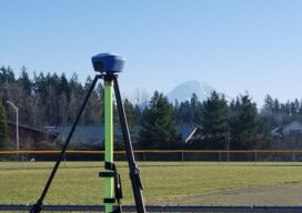
GNSS on Bench Marks?
The GPS on Bench Marks campaign of the National Geodetic Survey is a triumph of constituency participation to improve the nation’s geodetic infrastructure. The initiative is seeing success, but also faces challenges. Multi-constellation support, and acceptance of short RTK/RTN observations, will add a productivity boost. The “GPS on Bench Marks” program of the U.S. National...
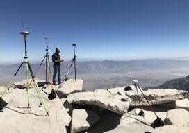
Citizen Geodesist
A GPS on Bench Marks odyssey Philip Melcher of Provost & Pritchard Consulting Group in Visalia, California, has submitted GPS on Bench Marks observations on an incredible 650 Bench Marks all up and down California in the last three years. We will ask Philip a few questions to find out how he has accomplished this,...

Can Mapping Bridge Urban Social Divides?
A new book contends mapping and spatial analysis can further the interests of under-resourced communities It sometimes feels as if there’s little that can bridge our society’s divides, but the married co-authors of a new book from Esri Press — one a Republican, the other a Democrat — are optimistic. “In city politics you can...
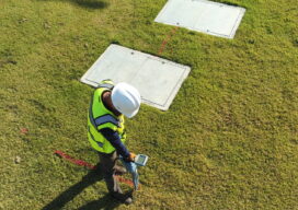
3D Models Above and Below
Aerial, terrestrial, and underground data tell the whole story Millions of miles of underground utilities provide U.S. communities with vital services, such as telecommunications, water, electricity, and natural gas. During construction projects, accidental damage occurs frequently due to inaccurate or non-existent documentation, a situation that can be exacerbated by inadequate research before excavation begins. Safety...