In the words of Will Cadell, “Geospatial is changing everything.”
That was not only one of the opening lines of a visionary talk by Cadell, founder and CEO of geospatial consultancy Sparkgeo, it seemed to capture the sentiment of exhibitors, speakers and attendees at GoGeomatics’ inaugural conference.
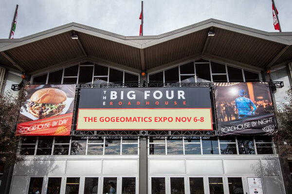
Held in Calgary, Alberta from Nov. 6 – 8, this first-ever Canadian national Geomatics and Location Technology Expo brought together 36 exhibitors, 74 speakers and 450 participants from industry and academia to share knowledge, network, and get insights into the geospatial future––particularly in the remote sensing space.
Co-located with the Expo was the debut GeoIgnite Career Fair, where Canada’s leading organizations had the opportunity to recruit from a diverse pool of professionals, including students and graduates from the Expo’s education partners, the University of Calgary, and the Southern Alberta Institute of Technology (SAIT).
For Jonathan Murphy, founder and managing director of GoGeomatics Canada, the idea for the Expo came from the desire to elevate the thriving geospatial industry in Canada.
“We don’t have a marquee national event that showcases the best of geomatics and Canada to the world,” he said. “I wanted to offer an event that would connect the Canadian geospatial community in a totally new way, that was fun and collaborative, and would not only get geospatial people excited, it would provide the opportunity for the public to learn about geomatics, get their hands on the latest tech and get them interested in it.”
Whether it was the convivial venue space, breadth and depth of speaker topics, myriad hands-on workshops, the active recruitment of geospatial career candidates, or perhaps the opportunity to geek out over the latest tech while sipping beer, the positive energy about geospatial now and in the future was palpable.
“The reach of geospatial industry is so vast and it’s ever changing with the incredible pace of technological advancement,” said Doug Kondor, founder and CEO of Cyanic Automation, creators of the Job Book project management software for surveyors. “It was not only incredible to have all this advanced technology in one place, but witnessing such an open, positive and collaborative community willing to network and share tips was really cool.”
Among the abundant discussion themes of reality capture/digital twins, Earth observation, BIM/GIS, surveying, leadership, education, government and geomatics for climate resiliency, three technology segments seemed to dominate almost every discussion I had: reality capture, lidar and drones. All three are pushing and redefining what’s possible in geospatial.
The reality capture revolution
From the workshops, presentations and discussions on the exhibit floor, the emphasis and examples of reality capture applications were significant.
“Reality capture is moving blistering fast,” said Dan McCarthy, president of Eagle Engineering and Consulting (Eagle-EAC). “It is changing and modernizing business practices for so many companies, including ours. It’s hard to keep up, but that’s also exciting.”
Reality capture technology and solutions now permeate throughout Eagle-EAC, transforming its turnkey solutions for telecoms and expanding its 3D services into new markets like municipalities. One of its newest 3D applications is manhole inspections using an inverted Leica RTC360.
3-D Line Locating, a utility and pipeline damage prevention solutions company, created a buzz with its NavVis VLX wearable mobile mapping system that offers highly detailed reality capture data for indoor and outdoor sites. The SLAM-based system is equipped with two, 32-layer lidars, each of which capture 1.2 million points per second and four cameras positioned on top of the device that take high-resolution images in every direction for a complete 360-degree image.
The company had only received the system a few weeks before the show, so it hadn’t been field tested yet. However, Michael Mayr, the company’s owner, confidently predicts that it will transform utility mapping and pipeline inspection and improve data deliverables by enabling crews to merge the above ground with the underground with exceptional real-world detail.
Reality capture seems to be everywhere. But, despite revolutionizing how we visualize, analyze and interact with our built environments, it is also presenting data integration, processing and standards challenges. Some technology users feel today’s software for processing and transforming voluminous 3D datasets has not kept up with the pace and innovation of the hardware. And a primary takeaway from a lively reality capture panel discussion is that industry experts and users alike want rules to be established surrounding the collection of this real-world data. This could be an opportunity for the Reality Capture Network.
New trajectories in Lidar
One of the more intriguing lidar stories centered on Quebec-based Balko Technologies, which aims to democratize lidar data capture with the launch of its Connectiv, the world’s first drone lidar modular sensor.
Completely swappable Riegl, Hesai and Velodyne lasers combine with Sony, ADTI and Microsense cameras to provide a fully configurable solution that offers relative accuracies ranging from 2-5 cm and precision from 1-7 cm. The Connectiv is light enough to fit smaller drones like the DJI-Matrice 300 series and depending on the configuration, it provides PPR rates of 100,000, 300,000 and 640,000. The cameras sync with an INS module for direct georeferencing and with its e-Connect app, users can start/stop sensor recording remotely and receive real-time status of the system’s INS, camera, lidar and storage.
Demonstrating some of its capabilities, Maude Pelletier, Balko’s CEO, showed video of the Connectiv configured with a Riegl laser performing a river survey with dense vegetation that achieved 2-cm accuracy.
“There is no other technology doing that in this environment right now,” said Pelletier. “That level of accuracy will completely change the caliber of hydrological mapping and modelling. We see the flexibility, efficiency and performance of this modular LiDAR solution transforming other sectors as well like transportation, construction and energy. Given its cost-effectiveness, I think you will see the demand for drone lidar becoming more and more common.”
Sam Rondeel, vice president of engineering at OGL Engineering, has already been witnessing a lidar evolution in the traditional power industry and in golf course design and marketing. Power customers used to only acquire lidar for a one-off survey; now the data is being collected regularly for integration into operations and maintenance for an asset’s whole life cycle.
In golf, lidar data has become an instrumental part of course design, facility management and marketing, and for one recent case, golf course restoration. Integrating geospatial data sources including lidar and a DEM, OGL produced a 3D digital twin of the Kananaskis Golf Course to help restore it to its original design after catastrophic flooding. A stunning 3D fly-through of the course was on display at OGL’s booth––the lidar density was so rich, I initially mistook the green pixels around the trees as leaves.
The dominance of drones
Physical drones and stories of drone-based applications were a fixation of the GoGeomatics Expo. Two examples in particular fascinated me.
One is Spexigon which aims to democratize drone data by crowdsourcing its collection.
Launched in 2022, the fly-to-earn drone imagery platform recruits drone pilots with DJI Mini 2 drones to fly available AOIs, capture imagery in a uniform way and receive crypto currency for their time and contribution. Interested pilots use Spexigon’s mobile app to select a spexigon––a “spatial hexagon” based on Uber’s H3 open-sourced hexagonal grid system––connects their drone to the app and clicks “Fly”. The Spexigon app automatically flies the drone along a pre-determined flight path to capture imagery at the correct height, speed and location. Once a 22-acre hexagon is flown, the high-resolution data is uploaded to Spexigon via its mobile app for processing. The company then owns the imagery to sell to organizations.
“The platform’s goal is to collect aerial imagery at scale to power better decision-making by organizations large and small,” said Graham Anderson, Spexigon’s operations lead. “And we can do it repeatedly at a fraction of the cost of traditional aerial surveys.”
In 2023, Spexigon crowdsourced 20 pilots to fly around 50,000 acres of the city of Surrey in British Columbia as a proof-of-concept. They captured 2,200 spexigons at 3-cm resolution in 18 days. They also covered the city of Kelowna, BC and have their sights set on other BC cities like Vancouver.
Another company that is redefining business as usual is Volatus Aerospace, which recently created a solution to quickly and safely detect buried mines and unexploded ordnance by dangling a magnetometer sensor from a drone. The system can also help identify mineral deposits and exploration targets for energy sectors.
Geospatial’s story is still being written
After three days of learning from academics, geospatial experts and users from industry and academia, the geospatial story has and will have many more chapters to include as it continues to impact, shape and transform our world.
The location data does indeed seem to be changing everything, but in Cadell’s view, more needs to be done to challenge the geospatial status quo.
“Our industry needs to be pushed out of its comfort zones,” he said. “There is colossal opportunity in geospatial and yet geospatial people predominantly make products for geospatial people. There are billions of lonely pixels that have never been looked at by the human eye but with our cloud computing, our culture of AI and algorithms and our open-source data, we have ample opportunity to get geospatial into the hands of everyday people and solve very specific consumer problems.”
We’ll have to wait for the next GoGeomatics Expo to see how much geospatial innovation has come from the industry’s collective discomfort. I encourage you to find out at the next show being planned for October 2024.