Category Archives: Hydro/Marine

Underwater Drones Search for Czar’s Lost Treasure
Continuing with our series (part one and part two) on the role that geospatial technology plays in treasure hunting, we come to the mysterious tale of the RMS Republic. Launched in 1903, the Republic was a part of the White Star Line, and, foreshadowing its sister-ship the Titanic, it sank six years later, 50 miles...

Outlook 2016: 40 Under 40
In this annual issue focused on the future, we offer “40 under 40” (or “40<40”): a collection of profiles of motivated and noteworthy young professionals under 40 years of age. It is our wish that these profiles will honor those who work tirelessly to promote geospatial fields and to provide inspiration for young people considering...
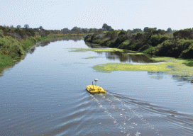
Aqua Bots
Above: The Z-Boat 1800 on a riverine hydrographic survey using sidescan sonar. Unmanned & Unlimited Unmanned aerial systems (UAS) get the lion’s share of media coverage, which is just not fair. Hardworking unmanned marine platforms, both surface and subsurface, have a lot to offer in the hydrographic surveying and inspection space. As a big bonus...
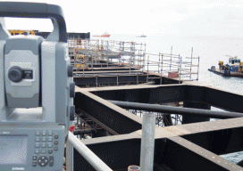
Stretching Surveyors across the Water
Surveying the Gorgon Jetty Project on Barrow Island off Western Australia involved integrating structural, mechanical, and hydrographic surveying technologies and skills. Barrow Island is described by some as Australia’s answer to the Galapagos Islands. The 202 km2 (78 mi2) island and its surrounding ocean are home to diverse and unique fauna, including marsupials, reptiles, sea...
Shannon Hoy
Graduate Student at the Center for Coastal and Ocean Mapping, School of Marine Science and Ocean Engineering, University of New Hampshire Many of the future’s motivated leaders in their respective fields gain a lifetime of experience while they’re still enrolled as students and student researchers. Young people interested in entering geospatial professions can read numerous...
Alexander Ustinov
Deputy Department Head at RusHydro’s JSC Institute HydroProject That the worlds of geospatial information, engineering, and high-precision positioning have been able to merge under an umbrella of real-time geodesy has been possible in part to the efforts of a new wave of “geo-renaissance” practitioners like Alexander Ustinov. With educational credentials that include the St. Petersburg...