Category Archives: Hydro/Marine

Night in the Afternoon: A US Solar Eclipse
What you need to know about the 2017 solar eclipse The upcoming solar eclipse will leave a 70-mile-wide trail of darkness across the United States on August 21, 2017 (see the map of the eclipse path on pages 44-45). This will be a once-in-a-lifetime event for many people. While another total solar eclipse will make...
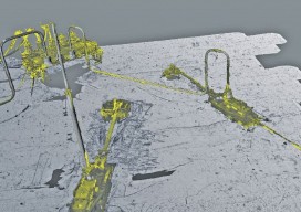
Surveying a Mile Down
Above: The metrology viewed as a combined model. A 3D surveying company provides highly detailed lidar data on subsea drill centers. This article almost didn’t happen. I first met with ADUS DeepOcean in January 2017, when we discussed how they had captured high-resolution laser data deep in the ocean off Ghana. Today, four months later, I...

The Hydrous: Mapping Vanishing Reefs
Using geospatial technologies, The Hydrous provides “open access” to oceans in an attempt to save critical habitats. The oceans of the world are vital to our survival. While monitoring their health is the realm of scientists and protecting their health is the responsibility of everyone, few of us truly experience the richness of these aquatic...

GEO Business 2017
Nicholas makes the annual pilgrimage to GEO Business for xyHt This blog is going to start with a short piece about skips. If you are afraid of skips (skips are what you’d call “dumpsters” across the Atlantic), turn away now …. Monday morning and 24 hrs from the start of GEO Business 2017, I get...

Ocean Business 2017
Last week, April 4th – 6th, one of the largest gatherings for the offshore industry took place, Ocean Business, in Southampton, UK. The bi-annual event is a large deal for the maritime industry. When I say large, I actually mean huge; there are over 350 exhibitors from 26 countries and 166 training and demonstration workshops...
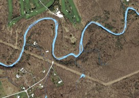
Mapping the Pennsylvania Lake Erie Watershed
Imagery was collected along 77 miles of shoreline to provide a better understanding of Pennsylvania’s natural resources. By Brian Stevens The Pennsylvania Lake Erie Watershed is a substantial part of the world’s largest surface freshwater system, the North American Great Lakes. The watershed is 512 square miles, consisting of 15 major sub-watersheds. It’s estimated that...