Category Archives: Hydro/Marine
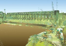
Capturing the Bluestone Dam
Above: Bluestone Dam is a concrete gravity dam located just upstream of the confluence of the New and Greenbrier Rivers near Hinton, West Virginia. Editor’s note: Because the Bluestone Dam is critical infrastructure, the Corps cannot display images of its insides. In fact, security is one of the key reasons it didn’t contract out the...
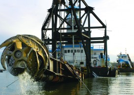
Survey. Dredge. Repeat: Keeping the Columbia River Navigable
As the skipper of Galileo 3, a 30-foot sailboat on the Columbia River, I tell my crew that I am comfortable with 15 feet of water under the keel, get nervous when it drops below 10 feet, and take immediate action if it drops below 6 feet. That’s because I cannot constantly monitor my chart...
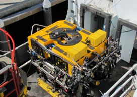
ROPOS: ROV Cool
I recently accompanied a film crew working on a documentary on maritime technologies to the NOAA facility in Newport, Oregon to catch a glimpse of what is widely celebrated as the “coolest ROV in the world.” The Remotely Operated Platform for Ocean Sciences (ROPOS) is the flagship research ROV of the Canadian Scientific Submersible Facility...

What is xyHt?
Stand in the place where you live Now face North Think about direction Wonder why you haven’t before “Stand” – R.E.M. Why an obscure geodetic expression? It’s not all that obscure—it represents a foundational element requisite to nearly all human endeavor. It touches your life explicitly and in the abstract. All of the ways that...
From Shore to Floor
Today’s technology records depth from land to deep waters accurately and efficiently. More than 90% of the world’s trade is carried by sea, according to the International Maritime Organization. Therefore, accurate and up-to-date charts of coastal waters for ship navigation are vital for world commerce. The current expansion of the Panama Canal, which will double...
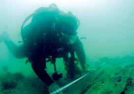
An Underwater World of Measurements, Positions, and Spatial Relationships
Most people assume that my job consists of digging big holes to remove shiny artifacts, swimming into an intact ship to, again, remove shiny artifacts, or, in extreme cases, using explosives to remove shiny artifacts. This couldn’t be further from the truth. Maritime archaeology seeks to gain knowledge of the past and preserve it for future...