Category Archives: Lidar/Imaging
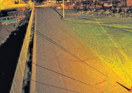
Prepping for El Niño
Above: A portion of a roadway that’s subject to flooding was scanned to perform drainage analysis as well as to map the existing conditions. As the severity of weather increases, so do the benefits of high-definition laser scanning for asset management and damage analysis. Editor’s note: Improvements in, and availability of, tools and resources for precise...
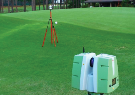
Visualizing the Perfect Putt
High-definition laser scanned topography-included in golfing greens contours books-elevates putting performance at the U.S. Open. It was two o’clock in the morning and pitch black, except for the red laser of the scanner. It pierced the darkness, accurately tracing the putting green’s profile. Michael O’Brien was enjoying perfect working conditions on the historic Pinehurst No....
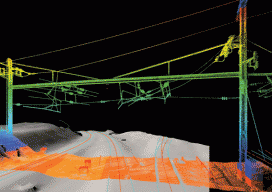
3D Overnight
Surveying the Arsenal Interlocking rail corridor in Philadelphia safely and efficiently with mobile lidar. An old section of the Pennsylvania railroad called the Arsenal Interlocking is now one of the busiest segments of rail for the Southeastern Pennsylvania Transit Authority (Septa) regional rail system. A high volume of trains operates in this territory due to the...
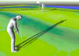
Golf Simulator: Unlocking the Mysteries of the Green
A new hyper-real golf simulator app developed with point clouds calibrates golf greens so golfers can raise their mental game. Every golfer knows, you “drive for show put for dough.” Yet, once the ball is within several yards of the hole, it seems to take on a mind of its own. It speeds up, slows...

Outlook 2016: 40 Under 40
In this annual issue focused on the future, we offer “40 under 40” (or “40<40”): a collection of profiles of motivated and noteworthy young professionals under 40 years of age. It is our wish that these profiles will honor those who work tirelessly to promote geospatial fields and to provide inspiration for young people considering...

Top of the Crop: Best of Pangaea 2015
As we end the year 2015, it’s interesting and informative to look back and see what you, our readers, found most interesting. Using metrics gleaned from our newsletter platform, I picked the top five issues for… Best of Pangaea 2015 Surprising UAS Section 333 Exemptions UAS continue to be a hot topic as the FAA...