Category Archives: Lidar/Imaging
Stretching Surveyors across the Water
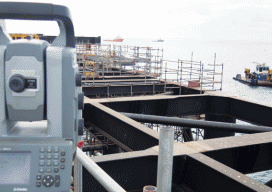
Surveying the Gorgon Jetty Project on Barrow Island off Western Australia involved integrating structural, mechanical, and hydrographic surveying technologies and skills. Barrow Island is described by some as Australia’s answer to the Galapagos Islands. The 202 km2 (78 mi2) island and its surrounding ocean are home to diverse and unique fauna, including marsupials, reptiles, sea...
Industry Profile: Brian Lingobardo
Systems Manager for 3D Road Construction at Topcon Positioning Systems Development of machine control, machine guidance, and automation for construction seeks surveying precision in real time, in dynamic environments, and in full 3D. Highly skilled surveyors have been included in automation development to ensure best practices for maintaining positional integrity and high precision. Brian Lingobardo,...
Joshua T. Rayburn
Mobile Mapping Manager at Leica Geosystems, NAFTA Lidar and mobile mapping systems may be getting easier to operate, but to operate them effectively and efficiently requires a helping hand in the form of training and support. Joshua Rayburn has grown a community of top-end users by focusing on creating strong customer relationships, and he’s committed...
Antonio Abellan
Associate Research Fellow and Lecturer at the Risk Analysis Group, Faculty of Geosciences and Environmenta at the University of Lausanne Switzerland is home to several of the world’s premier geospatial research and development institutions; some call it the Silicon Valley of the geospatial world. Many of the top minds in the related disciplines have been...
James R. Nicolau, IV
Project Manager for Land Surveying and 3D Scanning at Psomas Surveying’s “ambassadors” to related professions and industries help elevate the stature of the profession; James R. Nicolau serves in such a role. As the son of a business owner and professional land surveyor, James was introduced to the profession at a young age. With every...
Serene Ho
Research Fellow at the Centre for Spatial Data Infrastructures and Land Administration, University of Melbourne We inhabit 3D space, so it’s logical that the implications of this reality are being studied regarding the fields of authoritative spatial data systems and cadastres. Serene Ho’s PhD research and publications investigate the social, organizational, and cultural aspects of...