Category Archives: Spatial IT/GIS
3D, GIS, VR… We’re in Cloud City
When the father of GIS, the late Roger Tomlinson, first imagined a computerized system for handling land inventory mapping more than half a century ago, did he imagine that GIS would become such an integral part of our lives? At a click of a button, we can access directions to where we want to go,...
Do Your Work Right (and You Can Be ‘Smart’ Too)
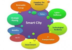
Ever since I saw the phrase “smart city,” I have cringed. Not because of the term but because of what it alludes to. To me it says that we (geospatial experts) haven’t done our work right. Let me explain. From Wikipedia: “A smart city is an urban development vision to integrate multiple information and communication technology...

GeoBusiness 2016 – London
Wow! Just, wow [ed. Translation to US-English “Wow!!”]. Last week I was at the UK Esri annual conference with 3000+ people crammed into the tight QEII conference centre. This still didn’t prepare me for GeoBusiness this year. It was the same venue as last year but somehow they’ve crammed in a few more stands, and...
Using CartoDB
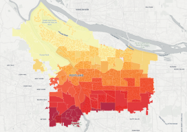
Above: This choropleth map of the distribution of street trees by neighborhood in Porland, Oregon, was created in CartoDB in eight minutes, using public data. From creating a map in eight minutes to creating market predictions based on streamlined analysis. Among the many mapping programs available, CartoDB stands out for its ease of use and sophistication....

UAS: It’s Unstoppable and Headed Your Way
From time to time I like to stop and think about the mission of Pangaea and explain that mission to you. My task is exposing you to new, emerging geospatial technologies. But why bother? Here’s a little analogy I thought of to help explain why keeping abreast of new geospatial tech is critical. Imagine emerging...
GISWORX 2016
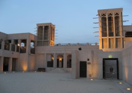
For most, work is a 9 to 5 grind that slowly eats at your core until you retire, find you have nothing to do, and get bored. Not if you work in the geospatial field though; everyday is a new adventure, and this month took me to the UAE, to be specific, Dubai for the...