Category Archives: Spatial IT/GIS

Pokémon Go Leads the AR Revolution
Six months ago when I claimed that augmented reality was the future of GIS and geospatial services, it was met with a few sniggers. This week has seen the arrival of Pokémon Go, one of the most popular games to hit the mobile phone market, and yes, it is augmented reality and yes, it is...

Pokemon Go: Geography Professor Pikachu?*
The single largest coordinated global geo-education event might just be … Pokémon GO! *Yes, aficionados have been quick to point out that the professor in the app is Professor Willow, but many readers might only connect the name Pikachu with the world of Pokémon. The title was intended to be a bit tongue-in-cheek. Below is...

Trolling: Always Get Independent Advice & Avoid the #geotroll
Ever since I started tweeting and blogging, I’ve received messages about using certain software, or how expensive a software is, or sometimes threats over my choice of software. It falls on deaf ears; I am independent. ANY geospatial software, no matter cost or design, is worth considering to some respect. Sure, some may meet your...
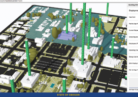
A State Gets Smart: SmarterBetterCities
To create and share interactive 3D building models, Oregon adopts SmarterBetterCities. To help formulate a 10-year strategic capital investment plan for the State of Oregon, the state’s Chief Financial Office (CFO) wanted to develop a dynamic, immersive, and collaborative visual platform that would illuminate key issues often lost in a tabular summary. Its audience was...
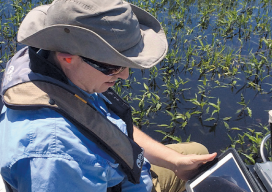
Fluid Data: GNSS and iPads
Lawrence Spencer puts the Trimble R1 GNSS receiver and iPad to work on the Kissimmee River. Pairing GNSS with iPads opens seamless data flows for a water management district in Florida facing wetlands complexity. Lawrence Spencer first joined the South Florida Water Management District’s (SFWMD) lake and river ecosystems section in 2006 as a...

Spatial Networking for Fun and Profit
Recently I attended a UAV event in my area (watch for the July issue of xyHt for more) that got me thinking about the role of networking in our profession. Not RTK, CORS, or even WANs or LANs, but person-to-person networking. Networking for fun. Meeting new people in the geospatial profession (and especially those interested...