Category Archives: Sponsored
Using Aerial Images to Improve Telecom Operations
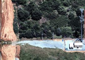
Sponsored Content As telecom companies work to keep systems and infrastructure operating, while innovating and adding new capabilities, they must find ways to be more efficient and cut costs. In this post, we talk with Nearmap’s Tim Frank, Senior Director of Marketing, to find out how telecom companies are using the latest aerial imagery technology...
[Webinar] Fast, Affordable Reality Capture for the Built Environment
Sponsored Content AEC professionals from top companies like Gilbane, Hensel Phelps, Mortenson, and more are using Matterport’s Pro2 3D Camera and Cloud platform to streamline workflows, minimize labor costs, accelerate BIM modeling, reduce site visits and travel costs, and to mitigate risk. Register for our webinar to learn how you can use Matterport’s 3D reality...