Category Archives: Surveying
Part 1: Foundations for Computing Error Ellipses
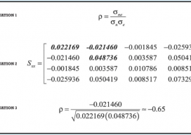
Standard Error Rectangle and Error Ellipse What is an error ellipse? One of the advantages of a least-squares adjustment over other methods is that a byproduct of the adjustment is not only the most probable values for the unknown coordinates but also standard deviations on these values Suppose for a moment that we are computing...

Back to the Moon? Or—Straight on to Mars?
Editor’s note: at xyHt and Pangaea we’ve been adding “geo-space-al” content into our geospatial mix, and readers have been responding positively. Surveying on Mars is a great example. When you think about it, geospatial technology and space are inextricably intertwined; from GNSS to satellite-based remote sensing, we rely on space-based technology to tackle almost every...

HyperStacking GPR
A new technology shows promise for enabling users to see deeper targets and operate in noisy conditions. By Jeffrey Feigin, PhD Editor’s Note: The field of ground-penetrating radar (GPR) is experiencing a new wave of development. For many of our readers, first impressions of legacy GPR gear included a lot of limitations and confusing images....

Strategic Movement: Precise Monitoring in Practice
A Danish company builds a successful monitoring business by leveraging technology and expertise. By John Stenmark, LS Newton’s laws of motion tell us that nothing moves if it isn’t pushed or pulled. That concept is behind the success of LE34, a Copenhagen-based surveying company that has built a business strategy around structural monitoring for a...

Cadasta: Mapping Land Rights from the Bottom Up
Above: Staff of the Kenya Land Alliance review a sketch map with community members while mapping water resources in Tana River County, Kenya. Credit: Hilary Ogina, Kenya Land Alliance. Cadasta helps put people on the map with a cloud-based platform for land-ownership data. By Matteo Luccio In advanced industrial countries we take much infrastructure for...

Your Local Knowledge Is King
Although the adage, “Your local knowledge is king,” could apply to other professions or even trades, I think it is especially true in our profession. When a surveyor practices in a given area or region, or possibly an entire state, knowledge is gained and lessons learned about many things that determine one’s ability to remain competitive,...