Category Archives: Surveying
Caught Mobile Mapping
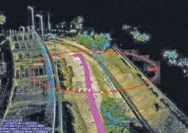
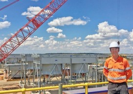
Above: Using a mobile mapping system, Construction CAD Solutions can generate high-accuracy point cloud data–in multiple views, as shown above and at left–to assist in its utility design function. Mobile mapping: A Chicago firm uses lidar innovation to survey for fiber infrastructure–for hundreds of miles. By Larry Trojak The ability to identify, accept, and then...
Surveying States: Different, Yet the Same
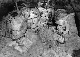
With the President’s Day holiday recently behind us, a day I refer to as Surveyor’s Day (think Mt. Rushmore) and National Surveyors Week starting on March 18, 2017, I can’t help but think about surveyors across the United States as a whole. Although my entire professional practice has been in California, over those years I have...
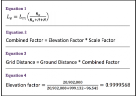
GNSS & Educational Equations: A Grid-to-Ground Project
When planning GNSS control surveys on highway projects, it is important to understand the limitations of GNSS. Most highway projects are long, and linear distances that are wide open horizontally and vertically and are ideal for GNSS surveying. However, in rural and city areas, tree canopies and high-rise buildings will obstruct the GNSS signals, so...
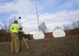
Championing GNSS for Surveyors
Lonnie Sears co-founded and runs Champion with dedication to training, quality, and cost. Editor’s note: The theme of this month’s issue is surveying innovation, so we felt it fitting to present the story of Champion Instruments. This firm was started by an American surveyor who responded to what surveyors were asking for and who has...
21st Century Survey: Milestone Surveys’ Innovation Makes a Global Workstation
Milestone Surveys is a digital child of the current century: working in the cloud and across the globe while maintaining fundamental surveying practices. Extinction is certain for geospatial companies that plan to make a profit tomorrow the way they did yesterday. In order to survive and thrive in the 21st century, surveying businesses must blend...
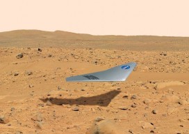
Surveying on Mars
The subject of Mars exploration and colonization is suddenly red hot. What role might there be for surveyors in this, the grandest of human endeavors? Above: The Prandtl-m is a conceptual fixed-wing drone for Mars mapping that will be tested this year from a balloon drop over Earth at an altitude of 35,000m to simulate Mars’...