 PSM December 2012
PSM begins our close examination of geodesy with the December 2012 cover story by V. Kelly Bellis, PLS, and we’re continuing it throughout 2014.
Shift Happens
You might wonder why PSM has been devoting so much content to gravity, datums, projections, and other geodetic matters and why we’ve brought Dave Doyle (NGS chief geodetic surveyor, retired) on board as our geodesy editor. It is because time (or, more rightly, the temporal component to geodesy) is starting to weigh heavily on the minds of many professionals who have not previously had to consider it. Times are changing; published positions move due to plate velocities, and the way we survey has had to adjust as the worlds of geodesy and land surveying merge.
Land surveyors, unlike their geodesist cousins, have traditionally been accustomed to working in a purely relative manner. Often for us, relationships between nearby boundary monuments and references are considered, but a basis of bearing may have no relationship with any kind of geodetic north, and the focus can be within a single PLSS section, or plat, or adjacent parcels. Then along came what are essentially geodetic tools and references: GPS and the National Spatial Reference Framework (NSRS).
Initially, this relatively caused no problems—published values could be held (“hold the HARN!”) and the GPS agreed. But decades have gone by since surveyors first set up their local reference networks: the earth moved, land subsided or uplifted, plates shifted. Then there are earth tides and polar tides to consider.
Now we know that the only “monument” that can be considered immutable (as far as geodesy is concerned) is the geodetic earth center. Now we have different ellipsoids, new realizations, active control (CORS), periodic readjustments of published values on passive monuments, and new gravimetric and hybrid geoid models—a recipe for confusion.
“A geoid cannot be bulldozed out of existence” is a sentiment often voiced by NGS chief geodesist Dr. Dru Smith. Indeed, as far as vertical reference is concerned, the NGS is encouraging the use of geoid models, as even NAVD88 is revealing flaws and infidelities to local mean sea level.
To help educate the surveying profession about geoids, PSM published V. Kelly Bellis, PLS’s excellent treatise on the increasing gravitas of gravity (part one in December 2012, part two in May 2013). Look those two articles up online and find links to Kelly’s original papers that include his stunning graphics and references.
Now, a new realization of the NSRS has been launched: NAD83-2011 Epoch 2010.00, a multi-year solution has superseded NAD83-CORS96 Epoch 2002.00 et al., and all of this is a whistle stop on to an eventual adoption of ITRF. For PSM, Dave Doyle authored, “A New Datum,” plus several editorial contributions giving the background on the current and planned reference framework changes in store from the NGS. Dr. Chuck Ghilani added several installments to his ongoing educational column, “Where Theory Meets Practice,” on plane projections and other methods and practices essential in properly applying these geodetic references and tools.
UPDATE:
GRAV-D Moves Forward
We’re at about 31%,” says Dr. Vicki Childers, GRAV-D project manager, giving the status of the ambitious nationwide gravimetric survey expected to be completed by 2020-2022. “The goal is to be able to replace the current vertical datum with a purely gravimetric datum by 2022.”
GRAV-D will incorporate the traditional terrestrial gravimetric data as well as data from the GOCE and GRACE satellites and substantial airborne gravimetric data (see “The Gravitas of Gravity,” PSM May issue, for a profile of an airborne gravity campaign). This will see the very best, state-of-the art elements combined to hopefully fulfill one of the goals of the current NGS 10 Year Plan (from the NGS GRAV-D website): “the gravimetric geoid used in defining the NSRS should have an absolute accuracy of 1 centimeter at any place and at any time,” although Childers pointed out that mountainous regions will likely not see 1 centimeter accuracy.
Does the new 2012 hybrid geoid incorporate completed elements of GRAV-D? “Not at this time,” says Dr. Dan Roman, geodesist with the NGS geoid team. “There will be a lot of rigorous testing before we roll out a hybrid geoid model based on that.” But there will be a gravimetric model available by early 2014 based, in part, on some of the data. “The model will stretch from the pole to the equator and from the end of the Aleutians to Puerto Rico,” says Roman. This will give the academic and scientific communities a chance to weigh in and use the data and test it before we see any hybrid model for use in the field.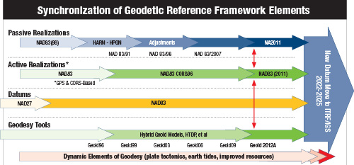 Some of the testing has come in the form of Geoid Slope Validation Surveys, like one begun in 2011 between Austin and Corpus Christi by the NGS.
The 300km-long survey included absolute gravimetric observations and GPS leveling, and astro-orthometric observations were also performed to determine deflections from the vertical, plus campaign GPS, RTN airborne lidar, and airborne imagery. The route was relatively flat. The next one is in flat terrain (across Iowa) but across the Midcontinent Rift, where the gravity field has a strong signal. The third one will have both a strong gravity and topography signal and will be in the Rockies, possibly. The data will be well tested long before the new gravity datum is made official.
The only thing that could hold up GRAV-D is a lack of funding. This sounds like a good cause for surveying associations to voice their support.
OUTLOOK
Instant Geodesy
Dream big. If someone on a survey crew decades ago were ranting about getting a position on the Earth down to a few inches within a few hours (or minutes, or even seconds), then back-sighting that with a robotic total station that can scan and do terrestrial photogrammetry, while a UAS buzzes overhead mapping the whole site … well, that person might have been eyed with more than a little suspicion. However, what we take for granted now was indeed being thought up by professionals in science, academia, and industry—even those decades ago.
When it comes to the geodesy, the future was being mapped by outfits like the NGS and the International GNSS Service (IGS—think of it as a global cooperative NGS). These forward-thinking people knew such tools and services were on the horizon, and they were quietly putting the reference framework elements into place so that we, the end users, can benefit from them. The dream of dynamic and instantaneous global geodesy is not new, but is getting much closer to realization.
Imagine being able to resolve the geodesy of every single surveyed point, not just the x, y, and H, but also the epoch (t); having it tied, earth-centered-earth-fixed (ECEF), to the global reference framework; and projecting it to whatever legacy system you need on the fly. Not far away, the National Spatial Reference Framework (NSRS) is likely to move to IGS/ITRF (2022-2025).
There is even a movement in the RTCM-104 committee (another international cooperative body that develops transmission standards for real-time GNSS) to add a position and baseline vector (PBV) message to the RTCM 3.x standard so that the geodetic reference metadata for the CORS/RTK Base/RTN will be directly passed to your receiver. Already RTCM 3.x has a transformation message placeholder so that you could someday be accessing a database of transformations/velocity models in real-time.
Imagine when GRAV-D is complete and kept up to date. Preliminary tests in Texas (GSVS11) by the NGS on completed portions of current geoid models have enabled crews to be able to transfer an elevation, down to the centimeter, over distances of as much as 100km. It is not inconceivable that you may someday see a gravity meter built into the base of the rod, and this could help resolve a hybrid geoid model in real-time.
Imagine augmentations with inertial gear, even electronic barometers to help maintain vertical under canopy (these have already been implemented on some devices). There may even be signal-based terrestrial reference systems to work with and, in some situations, replace GNSS as the primary reference (like Locata). You can thank the professionals working tirelessly on perfecting these geodetic reference elements and tools.
How far could this all go, for the good and perhaps for the bad? Will instantaneous geodesy lead to a whole new wave of careless button-pushers? Not necessarily—it takes a lot of education and skill on the part of the people dreaming up all of this, but certainly there is a lot involved in successfully implementing the magic they provide for us. It behooves us to stay on top of it and to dream big.