xyHt in print May 2016 Archives
Kespry: Anatomy of a UAV Start-Up

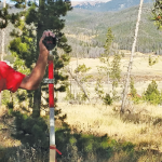
Above: CEO and founder Paul Doersch, a Stanford alum, explains Kespry’s unique rental/cloud arrangement. Kespry offers much more than a bird’s eye view. Take a computer scientist from Stanford University (who’s worked in Silicon Valley doing research for BMW on self-driving cars and smartphone integration) and add some grads from MIT and Cal Tech (with […]
The Certified Theoretical Monument
Igor Kidinsky, aka Eager (The Kid), estimated that both monuments—for the same property corner—were to be found nearby. Glenny Dale, aka Glutton (The Old Man), turned on the metal detector, but both surveyors soon spotted the old, grayed stakes in the shadows and knew they had found their pins. The task was to determine which […]
senseFly’s Andrea Halter: From Academia to the Market

Above: This eBee Ag is outfitted with the Sequoia multispectral sensor. An interview with senseFly’s Andrea Halter Andrea Halter is a co-founder of senseFly, a Parrot company based in Switzerland that develops and produces aerial imaging drones for professional applications. Halter oversees the company’s marketing and sales teams. She’s a qualified land surveyor and holds a […]
Ten Minutes
Invest time in the future of the profession—fill out the questionnaire! Editor’s note: This column continues to provide monthly coverage of the Forum on the Future of Surveying (FFOS): a national initiative with representatives from 15 key surveying-related associations to examine paths forward for the profession. See the first installment in our March issue. One […]
Crossing the Barrier
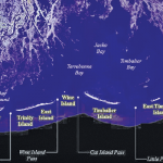
Above: The Barrier Islands off the Gulf Coast are threatened by coastal land loss. A Louisiana university overcame a barrier facing scientific research of coastal land loss—with a UAS. “We are losing an acre of coastline every 30 minutes,” says Dr. Gary LaFleur Jr., associate professor of biological sciences at Nicholls State University in Louisiana. And […]
Using CartoDB
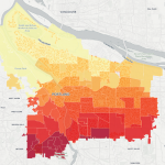
Above: This choropleth map of the distribution of street trees by neighborhood in Porland, Oregon, was created in CartoDB in eight minutes, using public data. From creating a map in eight minutes to creating market predictions based on streamlined analysis. Among the many mapping programs available, CartoDB stands out for its ease of use and sophistication. […]