Tag Archives: 3D CAD

Repositioning GIS
The technology that will drive the next era Esri calls GIS the nervous system of the planet, a platform relevant to almost every human endeavor. It’s a way to display, manipulate, and analyze geospatial data—and that ability is ever changing and expanding across industries. GIS technology allows us to derive location intelligence from spatial and...
BIM: Some Assembly Required (But not as Much as You Might Think)
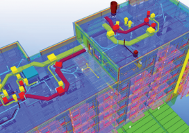
Above: A 3D model combines building structure, systems, and site data. Trimble’s Bryn Fosburgh Talks BIM Editor’s note: From a distance, BIM looks like it would present quite a challenge to implement: how to affect smooth and efficient workflows encompassing diverse and complex elements. As surveyors and other geospatial practitioners try to get their arms around...