Tag Archives: 3d modeling

Encoding Geography: Scale Up to Keep Up
America’s foremost community of professional geographers wants all students, especially women and minorities, to have a head start in geocomputational abilities. A revolution in teaching geography is in the offing. Demand for professionals with geospatial skills is on the rise. In 2019, expertise in geospatial technology was listed by Upwork, a global job website, as...

New Digital World Needs Data
Next-generation surveyors require specialized education and training to fill the role of geospatial data specialists. Many emerging geospatial applications, such as digital twins, 3D modeling, monitoring, virtual reality, and autonomous vehicles, are based on big digital datasets. Building a 3D digital world starts with accurate data that ties to a point on the ground, so...
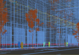
Creative Uses of 3D Modeling
The 3D data collected with laser scanners and digital cameras can be used to create digital and physical 3D models that have myriad applications—from marketing a new building to routing first responders in an emergency.

xyHt Weekly News Recap: 04/30/2021
Ingenuity Breaks New Ground for UAVs – on Mars GeoMax Introduces New X-PAD 365 Service Platform Woolpert to Provide Topographic Map for Nigeria Pix4D Launches Survey-Grade 3D Modeling on Mobile Devices Next GPS Block III Satellite Set to Launch in June ScaleOut Software Expands Digital Twin Streaming Service Leica Introduces GS18 Rover with Visual Positioning...
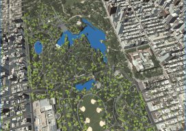
Automated City Extraction
Above: A portion of New York’s Central Park and surrounding neighborhoods, as automatically parsed into GIS data and reconstructed into 3D models by Geopipe. A new company called Geopipe builds 3D models using machine learning and AI, but with no photogrammetrists? A couple of weeks ago I found myself on a video call with a...