
Next-generation surveyors require specialized education and training to fill the role of geospatial data specialists.
Many emerging geospatial applications, such as digital twins, 3D modeling, monitoring, virtual reality, and autonomous vehicles, are based on big digital datasets. Building a 3D digital world starts with accurate data that ties to a point on the ground, so everything correctly relates to everything else for designs and measurements.
Demand for trained surveyors to obtain that data offers attractive opportunities that go far beyond boundary surveys. Additional training and expertise with advanced surveying technology is needed.
To properly prepare workers, educational curriculum and training programs must be updated to include 3D laser scanning, hydrography, photogrammetry, topographic surveys, remote sensing, geodesy, 3D modeling and monitoring with point clouds, and other topics, in addition to traditional property surveying.
The situation today
Surveyors have utilized the basic principles of measurement for thousands of years; however, new technology has vastly altered the methods used to complete mapping projects. With GPS/GNSS, laser scanners, mobile platforms, drones, etc., the collection process is faster and more accurate than ever before.
Data verification in the field helps ensure quality and completeness, while real-time data transfer to the office avoids delays in processing. Major improvements in software have automated many previously manual tasks and also enable integration of data from a variety of sources. The many changes in technology have led to discussions about the basic skill set that is required for this kind of work, as well as what kinds of additional training are needed in certain specialty areas.
“Our profession needs to take a good hard look at ourselves and separate out the key tasks and identify the expertise needed to complete the job,” says Tim Burch, executive director of the National Society of Professional Surveyors. “We may have to look at surveying like the medical profession. There used to be only general practitioners, but now we have specialists who are experts in their specific fields. Surveying technology has become so complex and varied, defining specialty areas could be the most effective path going forward. One person can’t be expected to know it all.”
Next generation surveyors
Identifying necessary changes in educational and licensing requirements goes hand-in-hand with efforts to attract the next generation of surveyor. Concerns about a shortage of qualified surveyors now and in the future are motivating members of the community to increase outreach to younger people and encourage them to pursue careers in surveying. However, re-writing the job description of a surveyor may be what is really needed.
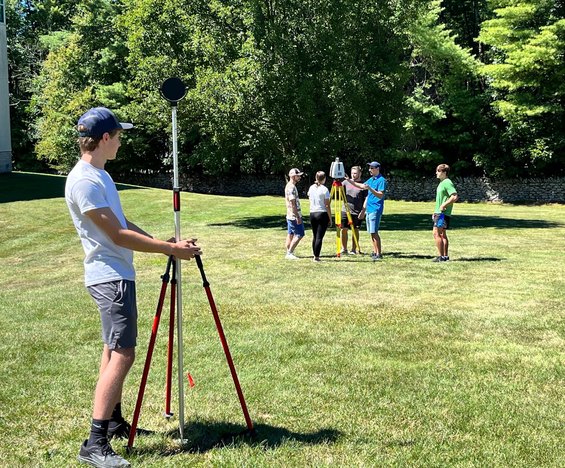
At Penn State Wilkes-Barre, surveying students take classes in the latest digital technology, such as terrestrial laser scanning. Photo credit: Jennifer Henniges
“To move forward and recruit the next generation of surveyors, we should try to incorporate the things they are interested in and leverage the computer skills they already possess,” says Burch. “There is a lot of value in the expertise required to operate specialized technology, but historically we’ve only emphasized getting the license.”
Labor needs are shifting as advanced digital technology increases the variety of geospatial applications. More diverse kinds of data are being collected and different deliverables are being produced. The role of the technician is becoming more important because the technology allows them to do more with less oversight.
Flexibility in the training requirements with options to develop specialized expertise could help attract the next generation to an interesting career while fulfilling the need for workers who understand geospatial data.
“We just attended our sixth American School Counselor Association annual conference with 250 other booths talking about occupations, and everyone was telling the same story – that we’re running out of people to work,” Burch says. “To better promote surveying, we need to communicate to the younger generation that the equipment and technology that surveyors use every day is actually building digital worlds, and they can contribute to that meaningful effort right now.”
Teaching the surveyor of the future
Survey programs at four-year academic institutions are at a crossroads. Interest among young people is waning and traditional courses do not reflect rapidly changing technology, while at the same time the industry is short-staffed and demanding more graduates. At Penn State Wilkes-Barre (Pennsylvania), one of only six accredited surveying/geomatics/geospatial engineering degree programs in the United States, program coordinator Dr. Dimitrios Bolkas recognizes the need for modernizing the curriculum.

Tim Burch represented NSPS at the American School Counselor Association conference in Boston.
“Over the past 20 to 30 years, the industry has been changing faster than academia could adapt. Updating courses can take a few years and bringing in new technology and instruments requires additional funding,” says Bolkas. “Currently, many programs focus on traditional land surveying, and it is challenging to integrate the new technology into the existing curriculum.”
Instead of trying to add a course here and there, the administration at Penn State Wilkes-Barre supported a full update of the four-year program. The process is time consuming, including preparing course descriptions, discussing each course with a professional advisory council, and consulting with other departments before the new courses are voted on by the university faculty senate. Staff with the necessary expertise in photogrammetry, point clouds, feature extraction, and other topics will also be added. Bolkas hopes the new curriculum will be ready by fall 2024.
Curriculum highlights
To prepare future surveyors, the revamped curriculum will include courses on laser scanning (terrestrial, airborne, and mobile), structure for motion, point cloud generation and processing, 3D modeling from the point cloud, monitoring applications with point clouds, feature detection and extraction from different platforms (terrestrial, airborne, and satellite), inertial navigation, and simultaneous localization and mapping (SLAM).
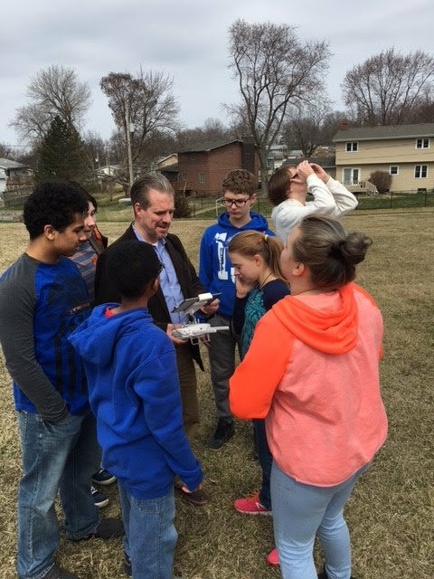
Tim Burch operated a UAV on a class visit to middle school math students.
Although it is necessary to retain the most important parts of traditional surveying (i.e., boundary surveying, land development, geodesy), some of this content is being pared down to make room for the new material. In addition, virtual reality training is being added to develop skills needed to perform surveys in the outside world.
“From an educational perspective, we always want to know how something works, how the algorithms affect the quality of what we’re doing, so it’s important to understand the basics,” says Bolkas. “It is very challenging for the surveyor to learn all of these different tools and integrate them into their workflows. We emphasize the sound background of skills such as geodesy, property law, and least squares, but also bring in the new.”
With a limited budget, gaining access to cutting-edge hardware and software is one of the hurdles faced by the academic team. The department owns a drone but would like to upgrade in the next few years. Leica Geosystems made a large donation a few years ago, which helped with access to robotic total stations and GNSS, as well as cutting-edge laser scanner technology and software, and partnerships with local companies provide other resources.
Borton-Lawson, a full-service architecture and engineering firm headquartered in Wilkes-Barre, has loaned equipment for research projects and teaching. To gain additional experience, students do internships during the summer and part-time internships during the academic year. The student chapter attends conferences of the Pennsylvania Society of Land Surveyors for networking and educational opportunities.
“There are early industry adopters who have already expanded their service portfolios by adding laser scanning, drones, and other new technology, while others are holding on to the familiar methodologies,” says Bolkas. “Although there is a slight lag in widespread adoption, the industry usually does a good job of modernizing its workflows to gain a competitive advantage. With demand for expertise in these areas increasing, our graduates hopefully will have multiple job offers when they graduate.”
Demand for geospatialists
High-accuracy mapping today provides the basis for future advanced geospatial applications, such as autonomous cars and deliveries. The surveying profession is evolving as the world becomes increasingly interconnected, and new requirements demand up-to-date skills and expertise.
The next generation of surveyors will leverage the high-speed, high-volume tools being developed, and use the data in unique ways. To keep up, academic institutions are in the process of updating their survey curriculum to incorporate advanced technology and workflows.
“I believe future surveyors will be expected to be expert geospatialists. They will be collecting and analyzing geospatial data, and making decisions based on geospatial information,” says Burch. “NSPS supports developing certification programs in many areas, such as hydrography and photogrammetry, while continuing to require professional licensing for projects involving legal boundaries and land transfers.”