Tag Archives: aerial
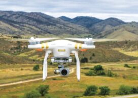
Safety is Paramount in Aerial Drone Mapping
As the Federal Aviation Administration (FAA) prepares to release its ruling covering uncrewed aircraft flights beyond visual line of sight (BVLOS) in the National Airspace (NAS) the entire industry is holding its breath preparing for a new era of certainty and expansion. Aerial photogrammetry will be one of the immediate beneficiaries of this new policy...

Hannah Peterson
23 Young Geospatial Professionals to Watch in 2023 – 8 of 23 Name: Hannah Peterson, Age 28Company: Aero-Graphics, Flight Planner Education: BS in Geology, Utah Valley University, MS in Geography, University of Utah All her life, Peterson has enjoyed spending time in the outdoors and learning about the earth’s processes. This led to pursuing and graduating...

Final Approach
The demise of a great mapping platform With the advent and adoption of new technologies, we are quick to forget about the old ways we used to do things. In the case of pocket calculators or disposable cameras is not relevant to reminisce about the past, but when the time comes to dispose of a...

Sanborn Relies on Vexcel Osprey Systems
Sanborn Relies on Vexcel Osprey Systems to Meet Growing Demands for Oblique Imagery In response to growing demand for oblique aerial imagery in the vegetation management, tax assessment, and 3D GIS markets, the Sanborn Map Company purchased two Vexcel UltraCam Osprey systems to better serve those applications. The Colorado Springs company replaced its existing oblique...
MAPPS President’s Message
Faster, Better, Cheaper By Robert Hanson We all know that expression. In theory this is the belief and the approach that drives an innovation economy within free, private markets. Ideally these three words are inspirational to all of us within MAPPS as they provide the thrust of purpose for our companies. At the macro-economic level,...
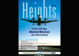
xyHt Magazine Heights 2022 Issue
Click on the cover to view the Heights 2022 supplement to xyHt magazine. Articles in the issue include: Mapping the Ocean: The need to map the surface of the ocean might seem odd, but as aerial technology advances, it is becoming more and more important. Manned Missions: In the age of unmanned aerial vehicles, the roll of the...