Tag Archives: Airbus

xyHt Weekly News Recap: 01/19/2024
Precise Positioning Takes Autonomous Capabilities to New Heights NV5 Geospatial’s Thermal Infrared Solutions Gain Traction for U.S. Infrastructure Challenges Airbus Helicopters to Expand UAS Portfolio with Acquisition of Aerovel Mapbox Unveils AI Features in New Navigation SDK ComNav Launches New P6H Handheld for GIS Elsight unveils its Worldwide Halo drone communications platform
xyHt Weekly News Recap: 03/24/2023
The American-Made CAP50 Drone Takes Flight Geo Connect Asia 2023 Draws Strong International Attendance Progress on Second-Gen Galileo Capabilities Graphisoft’s Archicad Collaborate Makes BIM Technology More Accessible This 89-year-old has Attended CONEXPO-CON/AGG for Six Decades Bluesky Partners with SkyFi to Widen Global Access to Aerial Imagery Airbus Signs Agreement with TerraNIS to Export Farmstar in...
xyHt Weekly News Recap: 12/23/2022
Worldwide Demand for Drone Services Anticipated to Reach $25 billion by 2033 USGS Recognizes Sanborn Expertise in AI/ML for Natural Resource Mapping Asia’s Leading Geospatial Event Returns to Singapore March 15-16 Airbus Hits Milestone on European Satellite-based Navigation Augmentation System Market for Commercial Earth Observation Data to Reach $7.9 Billion by 2031 Satellite Demand to...
xyHt Weekly News Links: 12/02/2022
Jack Dangermond to Keynote at Geo Week 2023 Presagis, Airbus to Provide Direct Access to OneAtlas Satellite Imagery Fugro Launches State-of-the Art Geotechnical Vessel for Safe Offshore Operations Nexar Releases CityStream™ Live, the Real-Time Mapping Platform for the Modern Mobility Age Xplore and UP42 Partner to Bring Satellite Data to Geospatial Customers Teledyne Geospatial to...
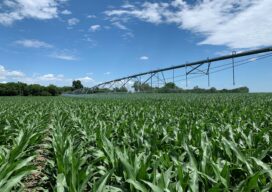
Farming From Space
Airbus and Sentinel Fertigation use satellite imagery to improve sustainable crop production With help from Airbus’ detailed high-resolution 30cm satellite imagery provided by Pléiades Neo, a Midwest crop management software platform is offering a streamlined process for farmers fertilizing crops via irrigation (known as fertigation). Using multispectral imagery of field conditions, Lincoln, Nebraska-based Sentinel Fertigation...
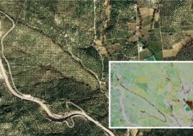
Sponsored Content: Pléiades Neo
The Satellites with the Highest Spatial Resolution are also the Most Accurate Spatial resolution grabs the headlines when a new Earth observation constellation is placed in orbit. And such was the case in 2021 when Airbus Defence and Space launched the Pléiades Neo 3 and 4 satellites with the highest native spatial resolution – 30cm...