Tag Archives: covid-19
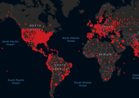
When Mapping Goes Viral
Digital mapping has boomed during the COVID-19 pandemic. From tracking cases to allocating vaccines, GIS technology is at the frontline of the war to beat the virus.

xyHt Weekly News Links: 5/15/20
CHC Navigation Introduces the Apache3 | 2020 Edition How to efficiently process satellite imagery Drones stepping up fight against COVID-19, says GlobalData Mapping large datasets on the web U.S. Department of Transportation Announces Technology Partners for Remote ID Development Everything You Need to Know about Scan-to-BIM
xyHt Weekly News Links: 04/17/20
MAPPS – COVID-19 Impact Webinar Series – REGISTER NOW! Hancock Associates Announces Promotion of Scott Jalbert, P.L.S. to Senior Vice President RIEGL Ultimate LiDAR Webinar Series How Will COVID-19 Impact the Present and Future of the Drone Industry? Esri Publishes The International Geodesign Collaboration Introducing OxTS Georeferencer – Helping You Create Accurate 3D Pointclouds Skytec...

In the Face of COVID-19: Keep Calm and Survey On
Coping with COVID-19 requires flexibility and planning. Don’t worry, this is not yet another article on how to wash your hands, stay home if you’re sick, and sneeze into a tissue or your elbow. I’m assuming you’re aware of the basics. Instead I focus on ideas for coping with COVID-19 should your geospatial business become...