Tag Archives: DOT

Sydney Fuhrig
23 Young Geospatial Professionals to Watch in 2023 – 1 of 23 Name: Sydney FuhrigCompany: Tennessee Department of Transportation Current Position: Planning Specialist Age: 23 Education: Bachelor of Arts in History and Environmental Science from the College of William & Mary Biography: At the Tennessee Department of Transportation Fuhrig trains colleagues in GIS, helps manage Tennessee’s roadway...

Sometimes It’s What They Don’t Say
When you’re trying to get something accomplished, it’s always disappointing to come up against that person who wants to disagree vehemently and debate the subject at hand. Sometimes when a surveyor is performing his duties to recover property boundary evidence in the field, the owner of an adjoining property may come along and try to...

Drones in Construction
For decades the construction industry didn’t change much-and then UAV technologies came along Unmanned aerial vehicles (UAVs) or drones, as they are commonly called, are mostly electric-powered aircraft, which do not require a pilot onboard and are used to perform tasks that are either too dangerous for humans to do or too expensive with other...

xyHt Weekly News Links: 07/30/2021
Trimble Boosts Flagship RTX Correction Services Performance Common Ground Alliance Releases Newest Edition of Best Practices Guide North Dakota DOT Selects GeoCue for UAS Program Esri to Expand Geospatial Innovation in St. Louis Area Commercial UAV Expo Exhibit Floor Nearly Sold Out dSPACE and Cepton Partner to Provide 3D Lidar Simulation infiniDome Debuts Anti Jamming...
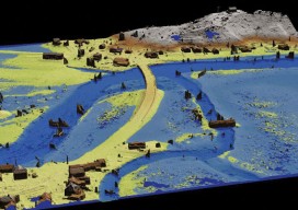
GIS-Ready sUAS
Producing GIS-ready 2D and 3D products to support decisions in transportation. Transportation planners and engineers have often made use of remotely sensed data such as overhead imagery and lidar for mapping, measuring, and monitoring transportation networks. However, despite its utility, remote sensing has failed to achieve its full potential. Remote sensing should be able to...