Tag Archives: drone

xyHt Weekly News Recap: 04/01/2022
Flood Protection Program Virtual Industry Day Set for April 21 Synspective, World Bank, and NDRRMA Assess Geohazards after Flood in Melamchi, Nepal Qualcomm, Trimble Introduce Meter-Level Location Accuracy for Smartphones India Undertakes Large-Scale Bathymetry Survey to Develop Coastal Economic Zone Intermap Supports Ukraine’s Ministry of Defense with High-Resolution Analytics CompassCom Announces the Launch of Compass.University...
xyHt Weekly News Recap: 02/25/2022
Register for NSPS Virtual Day on the Hill by March 1 Aero-Graphics Contracted by U.S. Army Corps of Engineers 3D at Depth Receives Patent for Monitoring Underwater Structures Lidar Survey Reveals More than 400 ‘New’ Archaeological Sites in England Airbus to Provide Imagery that Enables Crop Analytics SkyGrid Launches All-in-One Drone App for iOS Globally...
xyHt Weekly News Recap: 12/10/2021
Microsoft and Esri Deliver Centralized Satellite Image Analysis in Azure Orbital NSPS Scholarship Applications Available USGIF Launches 2022 Scholarship Campaign NVIDIA is Building a Digital Twin of the Earth Task Force to Review Connectivity and Technology Needs of Precision Agriculture Geo Week Early Bird Pricing Ends Dec. 17 One Year from Launch, U.S.-European Satellite...
xyHt Weekly News Recap: 11/19/2021
NSPS 21st Annual Student Competition Bushfire Mitigation through Machine Learning with AusNet and AWS Register for 11th Utility Investigation School in Golden, Colorado Young Surveyors Network to Meet Dec. 4 Fugro to Update Cayman Islands Hydrography for UKHO with Carbon-Neutral Survey Scan to BIM In Minutes Webinar on Nov. 30 Global Navigation Satellite Systems Market Expected to Grow 8.2% During...
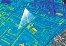
Protecting Urban History
Maximizing the data collected from airborne lidar helps protect historic structures in older cities In Part I last month, we outlined the research performed in Dublin, Ireland, and Brooklyn, N.Y., using hyperspectral scanning to help old cities protect historically significant buildings during new construction projects. In Part II, NYU professor, Dr. Debra Laefer, explains how...
xyHt Weekly News Recap: 10/22/2021
Geo Week Conference Program and Speaker Lineup Announced Alpine 4 Holdings Debuts on NASDAQ; Announces the Acquisition of Identified Technologies DGT Associates Launches Owned Subsurface Mobile Mapping System Esri Partners with The Ray to Map Solar Energy Hot Spots Proven Drone-Based Automatic Dent Inspection Maps an Entire Rafale Fighter Jet in Just One Hour What...